
Since Spring 2020, I’ve been getting outside and hiking to waterfalls near the Twin Cities, Southern MN, and the beautiful North Shore. I set a goal of exploring & photographing the best 52 waterfalls I could find locally.
I’ve been posting them on Facebook each week under the hashtag #WeeklyWaterfalls and people have been asking a lot of questions about which ones are best and where exactly they are. I thought it would be good to organize them here.
Here, you can see the waterfalls organized into area of the state and the rankings (5 stars – best) I gave each of them. Below, there are pictures of all of the waterfalls, a description that will help you see them, and a link to a map pinpointing the location of each one:
TWIN CITIES WATERFALLS ———————-
St. Anthony Falls (*****) – Minneapolis MN:
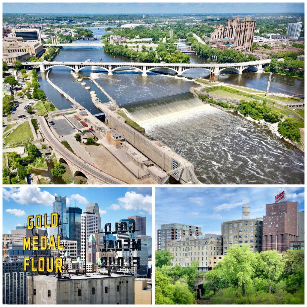
This is the hardest working of all Minnesota waterfalls, right in the middle of Minneapolis. Although the collapsing natural limestone falls were capped with a concrete overflow in the 1970s, they are still a spectacular sight. Stand here and imagine that for a century the falls powered massive flour mills (Pillsbury & General Mills) on both sides of the Mississippi, making Minneapolis ‘Flour City’. The falls were joined by the Great Northern Stone Arch Bridge in 1883, which is now a scenic walking/biking bridge. MAP
Minnehaha Falls (****) – Minneapolis MN:
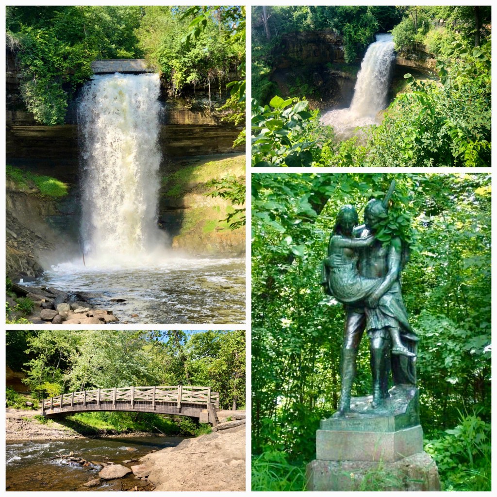
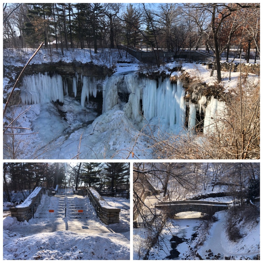
Minnehaha Falls is named for the star of Henry Wadsworth Longfellow’s 1855 epic poem ‘The Song of Hiawatha’. In the story, Minnehaha is a tragic indian maiden whose name means ‘laughing water’ or waterfall. This historic waterfall has been visited by US Presidents and dignitaries since it became a park in 1885. At the top of the falls stands a statue of Hiawatha carrying Minnehaha across the creek. MAP
Hidden Falls (**) – St. Paul MN:
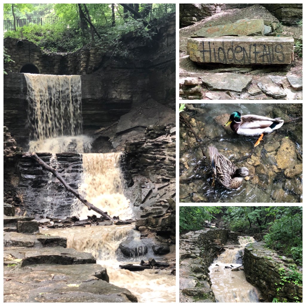
One of St Paul’s first parks, Hidden Falls and it’s small waterfall play the red-haired step-child to rival Minneapolis’ much larger and poetic Minnehaha Falls across the river. Still, Hidden Falls has a wonderful location at water-level with the Mississippi River. The small, multilevel waterfall here is best seen after a rain storm – look for it on the far north end of the park behind the picnic pavilions. MAP
Ford Dam (**) – St. Paul MN:

The 574’ wide Ford Dam, officially known as Mississippi Lock & Dam #1 was built in 1933. It turned 4 massive (15-ton) turbines that powered the mighty Ford Assembly Plant that once stood just to the east of the dam in St. Paul. MAP
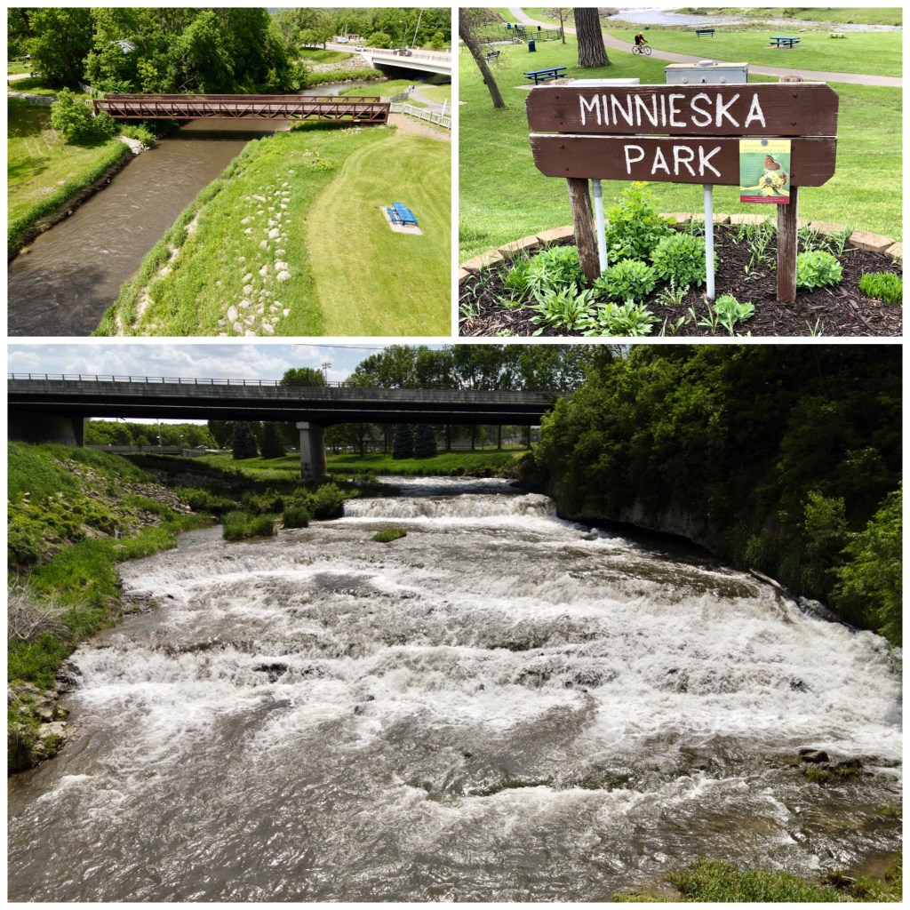
Rum River (**) – Anoka MN
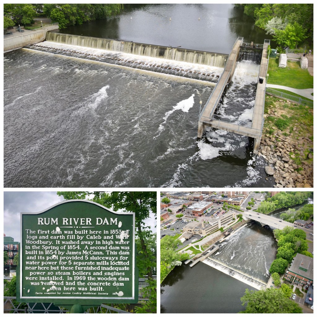
The Rum River powered as many as five flour mills in Anoka since before the Civil War. The Lincoln Mill became part of Pillsbury in the 1880s until it was closed & demolished in the 1930s. Downtown Anoka is filled with great restaurants and shops. MAP
Shadow Falls (*) – St. Paul MN:
Nestled near the western point of Summit Avenue – where it meets East River Parkway – Shadows Fall Park is typically no more than a slight trickle. It’s still a fun place to climb around and enjoy the amazing Mississippi River views – popular with nearby St. Thomas college students. MAP
Coldwater Spring (*) – Minneapolis MN
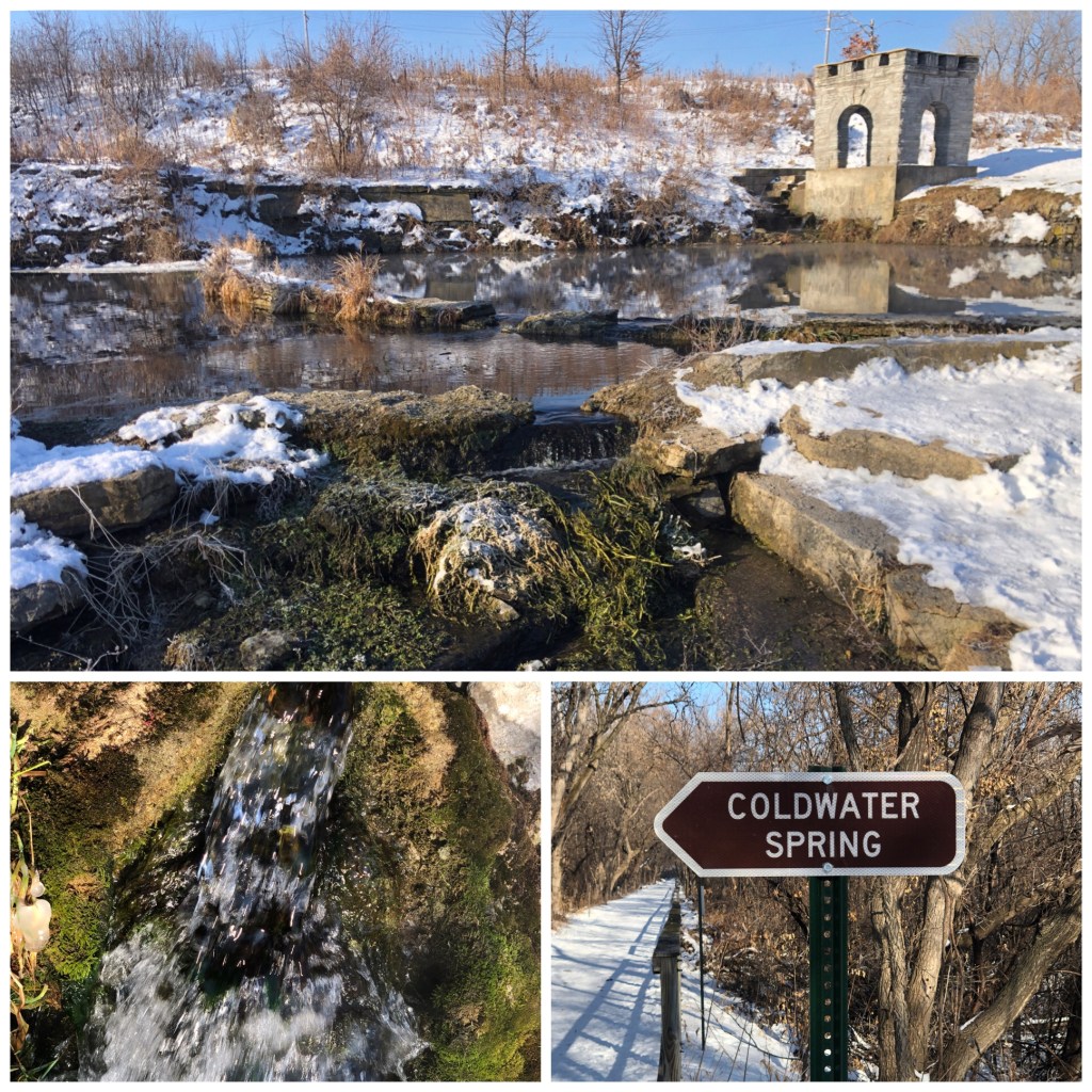
This tiny series of cascades has a huge history. Archeological evidence indicates that people have lived near this natural spring for 10,000 years. That’s as old as the ancient Elisha Springs in biblical Jericho. Coldwater flows year-round with aquatic greenery growing even in frigid January. MAP
Lake Phalen Waterfall (*) – St Paul, MN
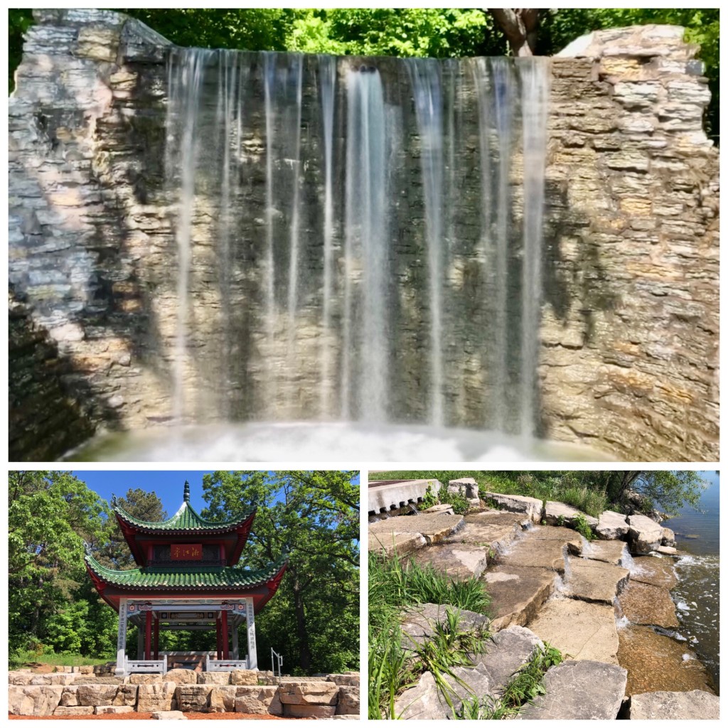
Restored in 2014, this 1950s waterfall originally pulled water from a deep well to maintain Lake Phalen water levels. Now it draws & gives back from the lake. It is nearby the St.Paul-Chinese Pagoda & Friendship Garden. MAP
Bennett Lake Waterfall (*) – Roseville MN
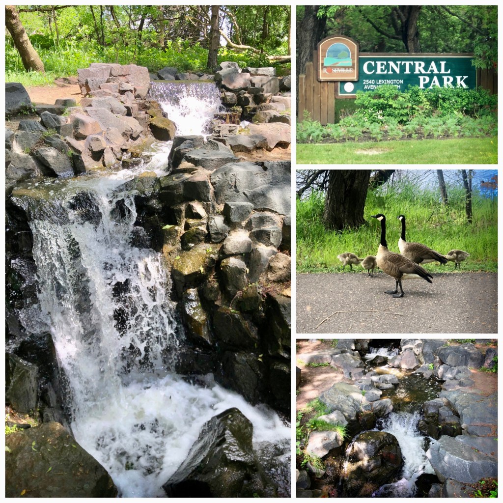
Geese and their goslings sometimes keep watch in the Spring near this small #WeeklyWaterfall on the east side of Roseville Central Park’s Bennett Lake. MAP
Normandale Park (*) – Bloomington MN:
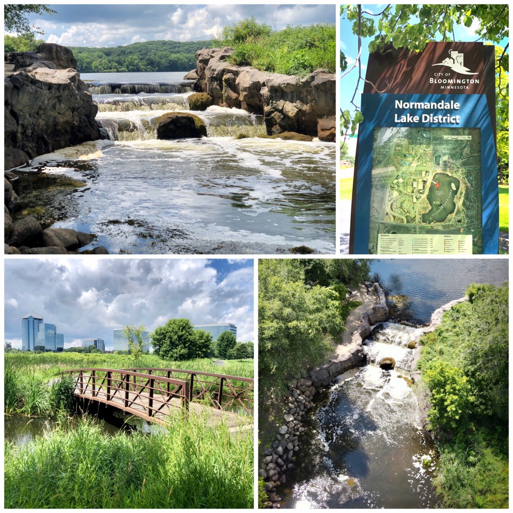
Few of the Twin Cities’ suburbs have waterfalls, but this little, man-made drop sits just off of I-494 on the east side of Normandale Park. Easily reached on a paved walking path from the bandshell on Lake Normandale’s north side. The path that circles around the lake is 2.1 miles. MAP
Mears Park (*) – St Paul MN
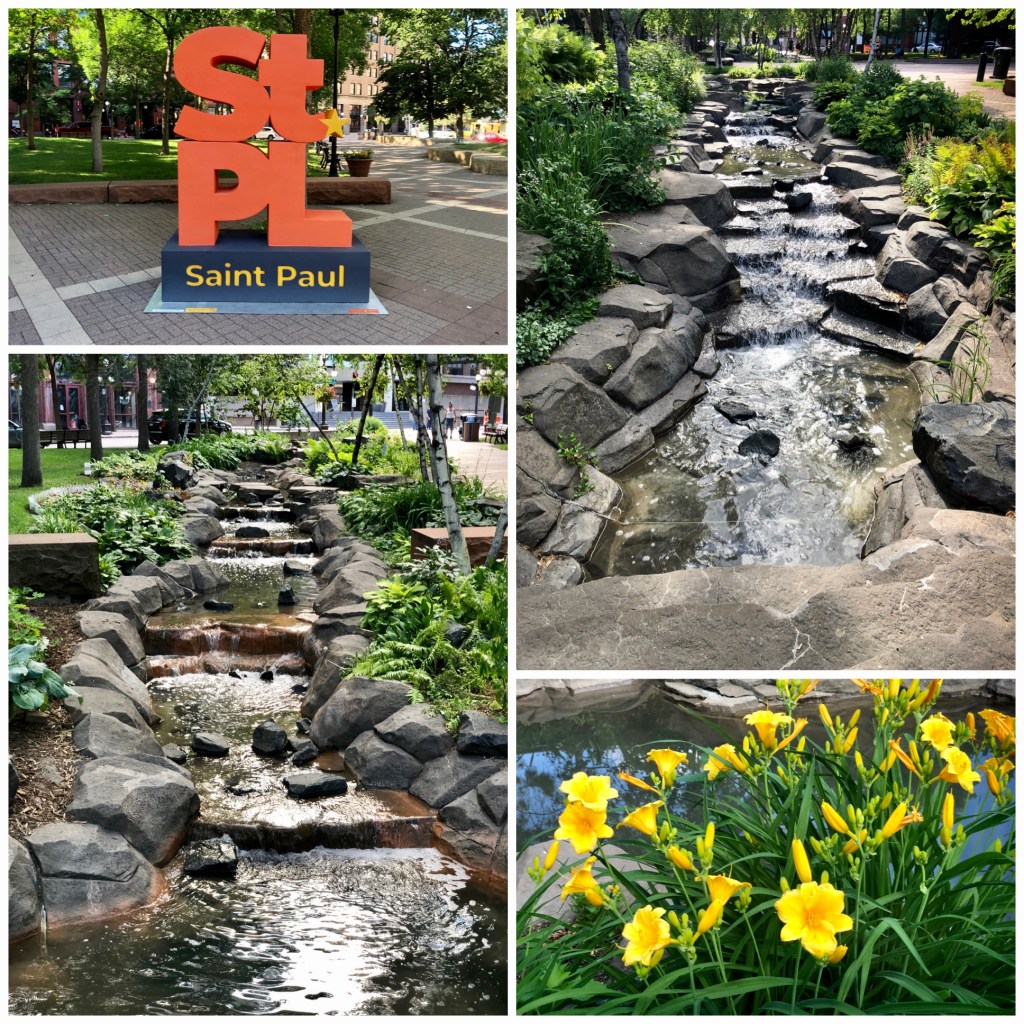
These two man-made cascades provide a nice visual & ambient sound to the concrete jungle around St Paul’s Lowertown Area. A nice stop in the city if you are out for lunch or heading to the nearby Saints game. MAP
ST. CROIX VALLEY / WEST WISCONSIN WATERFALLS ———————-
Willow River Falls (*****) – Hudson WI
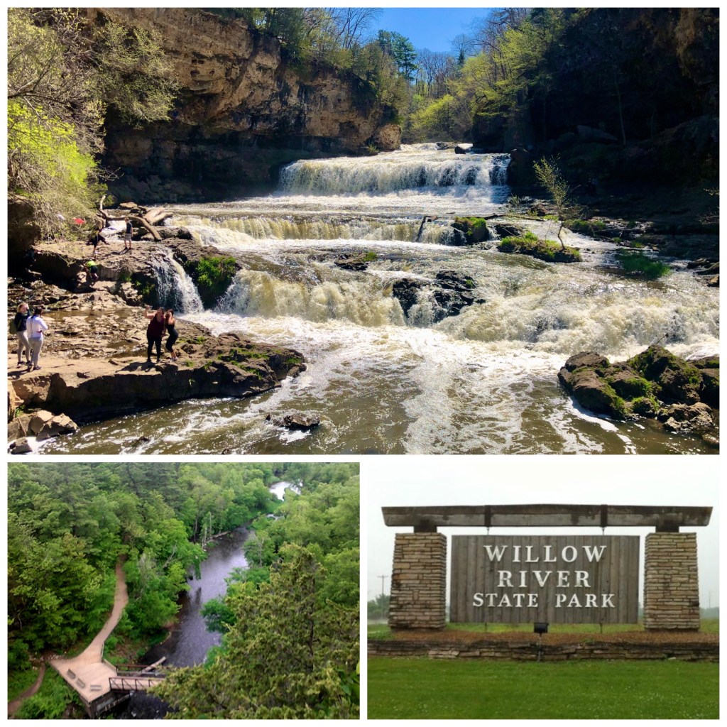
Just a short 15 mile drive from the Twin Cities. Willow River Falls is one of the areas best kept secrets. A spectacular, multi-drop, 45’ waterfall – over 100’ wide – was restored when a hydroelectric dam was removed in 1992. Willow River is great for families – kids & adults are both in the water all summer long. Park with a WI State Parks pass or pay the day rate and hike down a steep hill about a half mile to the gorge. MAP
Fairy Falls (***) – Stillwater MN:
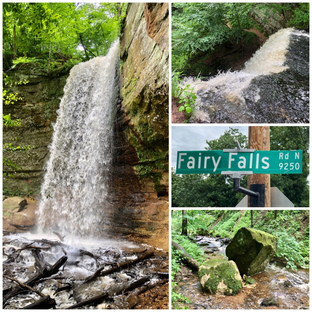
Fairy Falls is a small park north of Stillwater MN with a discrete entrance off its namesake road. Since it is a very steep park with very little parking, I found it better to park in one of the two parking spaces right at the dead end of Boom Road and look for the unofficial path at the end of Boom Road toward Silver Creek. Once a few feet into the woods, you can follow the footpath up Silver Creek to Fairy Falls itself, which has an amazing 40’ drop. MAP
Vermillion Falls (***) – Hastings MN:
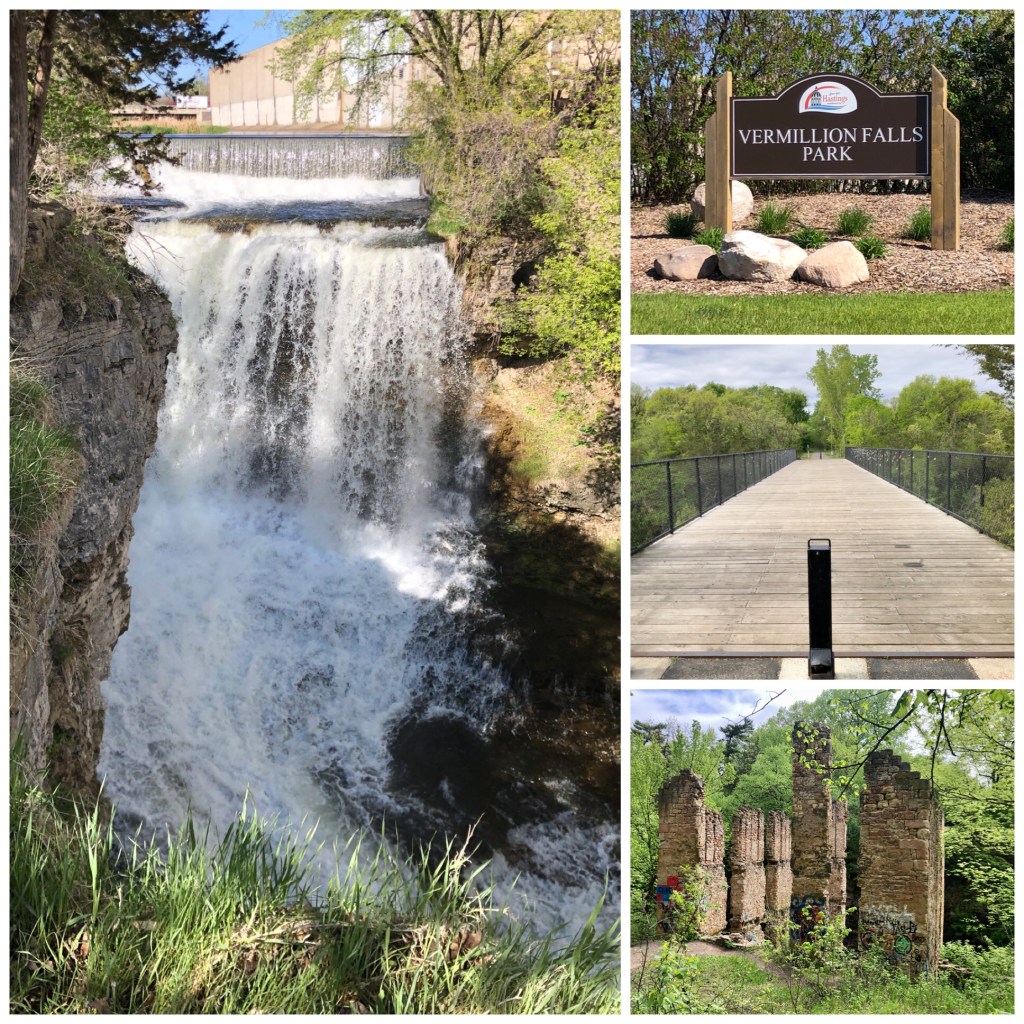
You won’t find an easier waterfall to get to on this list than Vermillion Falls in Hastings MN. A giant modern mill overshadows this 35’+ drop that is just steps from the free parking area. Continue east on the paved walking path and you’ll cross a lovely bridge decked with ‘love locks’. Even further are the Vermillion River rapids and remains of the 19th century Alexander Ramsey Mill. MAP
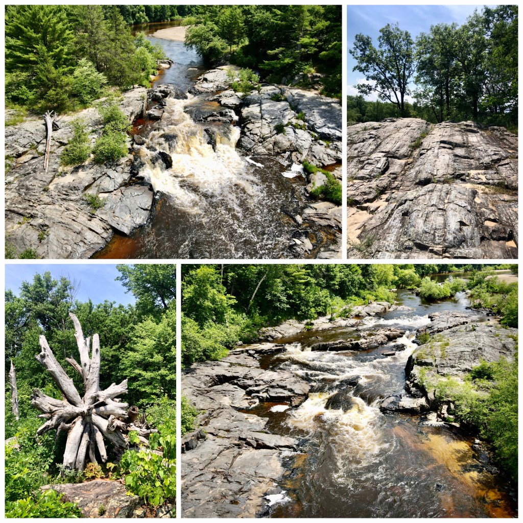
Cascade Falls (***) – Osceola WI:
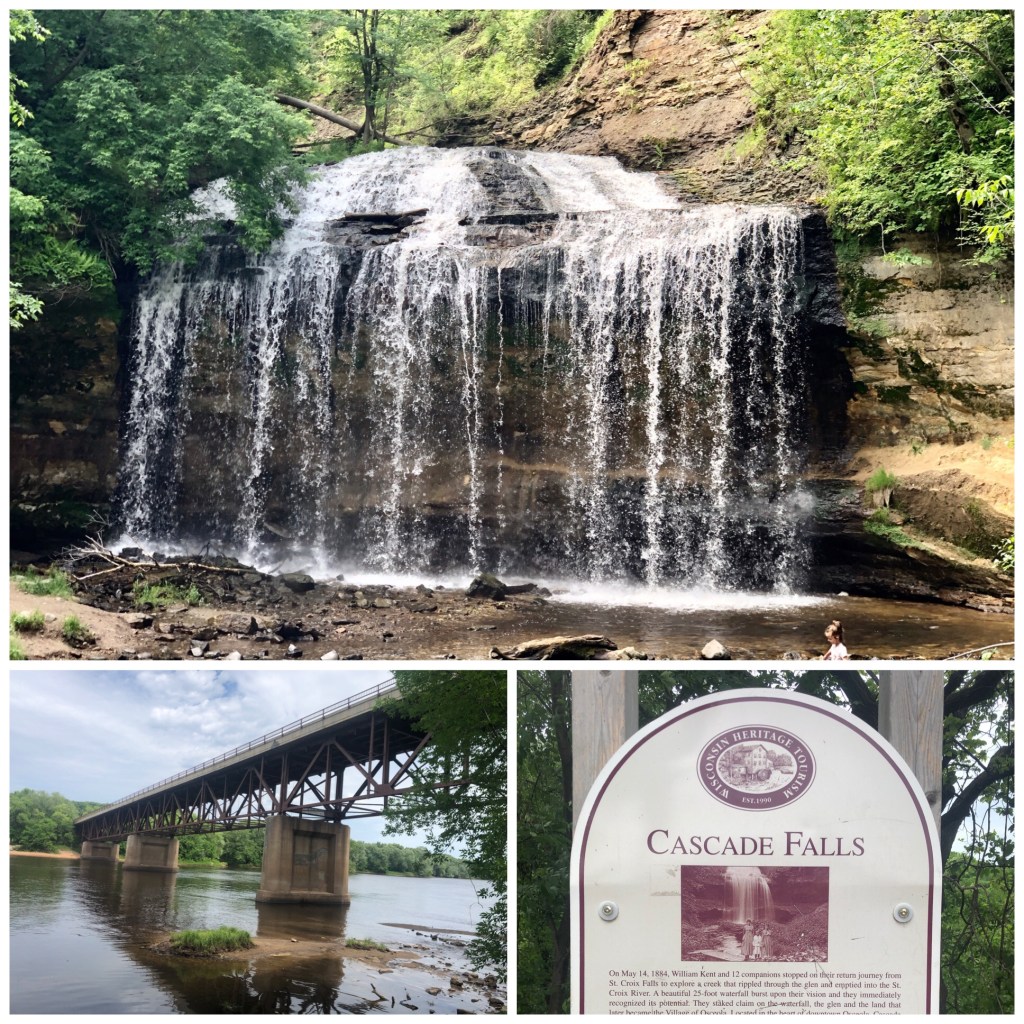
These 25’ falls seem to flow well regardless of how much rain has fallen recently. Park downtown Osceola and descend about 135 steps to the falls basin, which has a few picnic tables. Kids can climb around the falls and the short trial that leads out to the St Croix River. MAP
Robinson’s Creek Falls (***), Scandia MN:
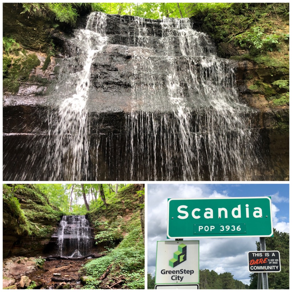
Robinson’s Creek is another close-by waterfall isn’t well-known. This #WeeklyWaterfall requires a little bushwhacking to get to, but you can get right up underneath the 20’+ gush. Park on Quint Road. MAP
Lake Redstone Waterfall (**) – LaValle WI
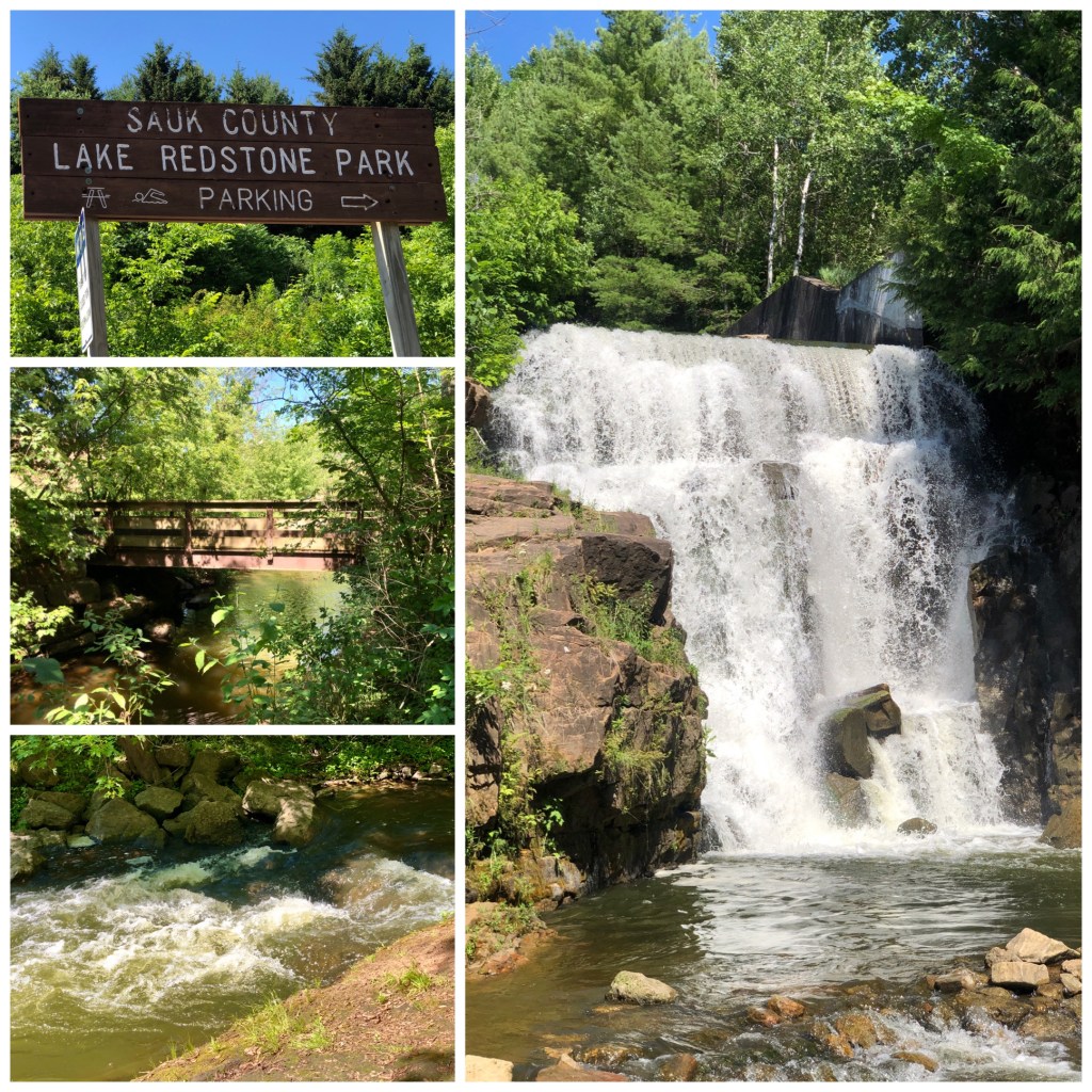
This waterfall is in a park west of Baraboo WI, not too far from Wisconsin Dells. It’s called Lake RedStone because of the reddish sandstone rock formations which border the lake. The double-drop falls are about 30’ high and manmade. It’s a spillway that connects the lake to Big Creek. $5 to park near the nice sandy beach area. MAP
St. Croix Falls / Dam (**), WI
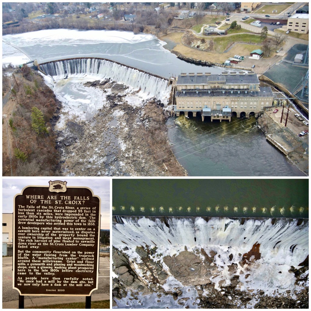
Many waterfalls have been replaced by hydroelectric dams, but this one is impressive. St Croix Falls once had cascading drops of 50’, but they dammed it up in the early 1900s. A sign at the nice overlook suggests the ‘progress’ was a big historical mistake. MAP
Marine Mill Falls (*), Marine-On-St Croix:
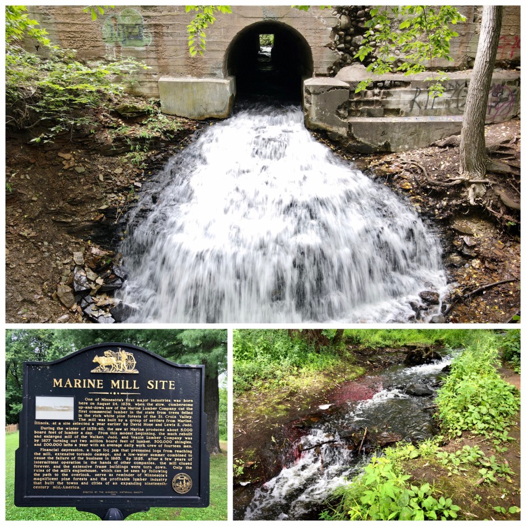
Fed by a creek that flows through the Brookside Tavern and under Main Street, these small falls have an important place in MN history. They once powered the state’s first commercial lumber mill (1839). MAP
Big Falls Park (***) – Eau Claire WI:
These double-sided waterfalls on the Eau Claire River don’t have huge drops, but have an interesting history. A UW-Eau Claire geology professor that I met here said they were formed from the remains of a mountain range 2 billion years ago. Parking is $5 for this county park. The walk is just a few hundred yards to the river. Bring your suit if you want to swim or get closer to the falls. There is a sandy beach / big sand bar that extends out into the water. MAP
Dells Mill & Museum (***) – Augusta WI
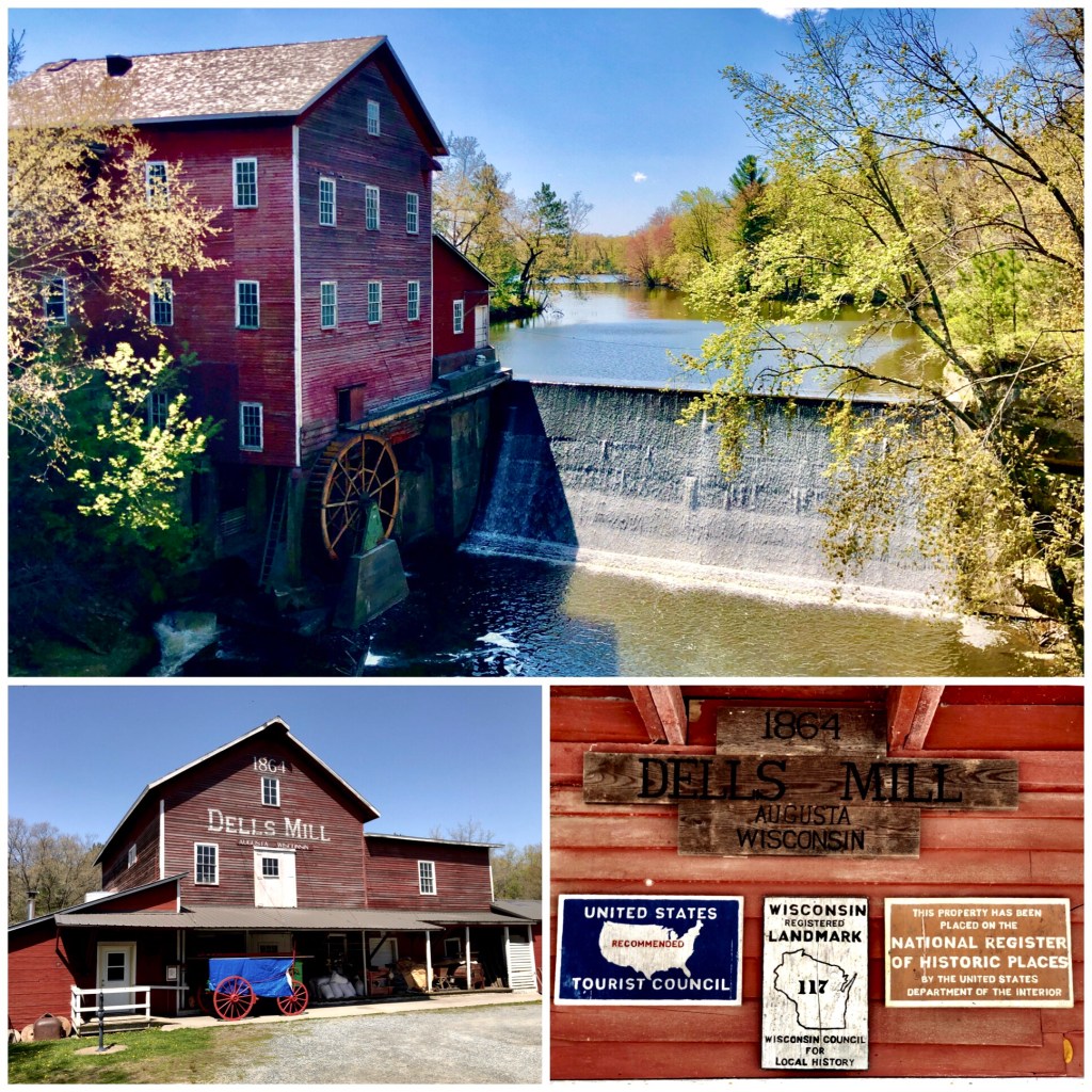
This historic 1864 water mill stands proudly on the Dells Millpond that feeds bridge creek. It’s in the National Historic Register and has a museum and shop open on weekends in the summer. MAP
Glen Loch Spillway (**) – Chippewa Falls WI:
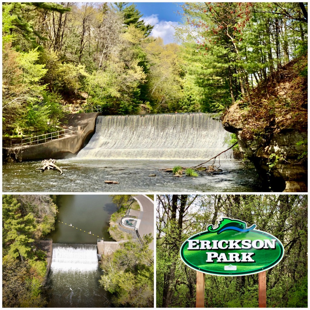
This scenic drop is just north of Chippewa Falls, where Glen Loch Lake spills into Duncan’s Creek. It’s a small, but picturesque area with the creek cutting through sandstone dells. Parking is easy and there is a kayaking facility integrated into the park. MAP
Star Lake Spillway (*) / Marshall Park – Chippewa Falls WI:
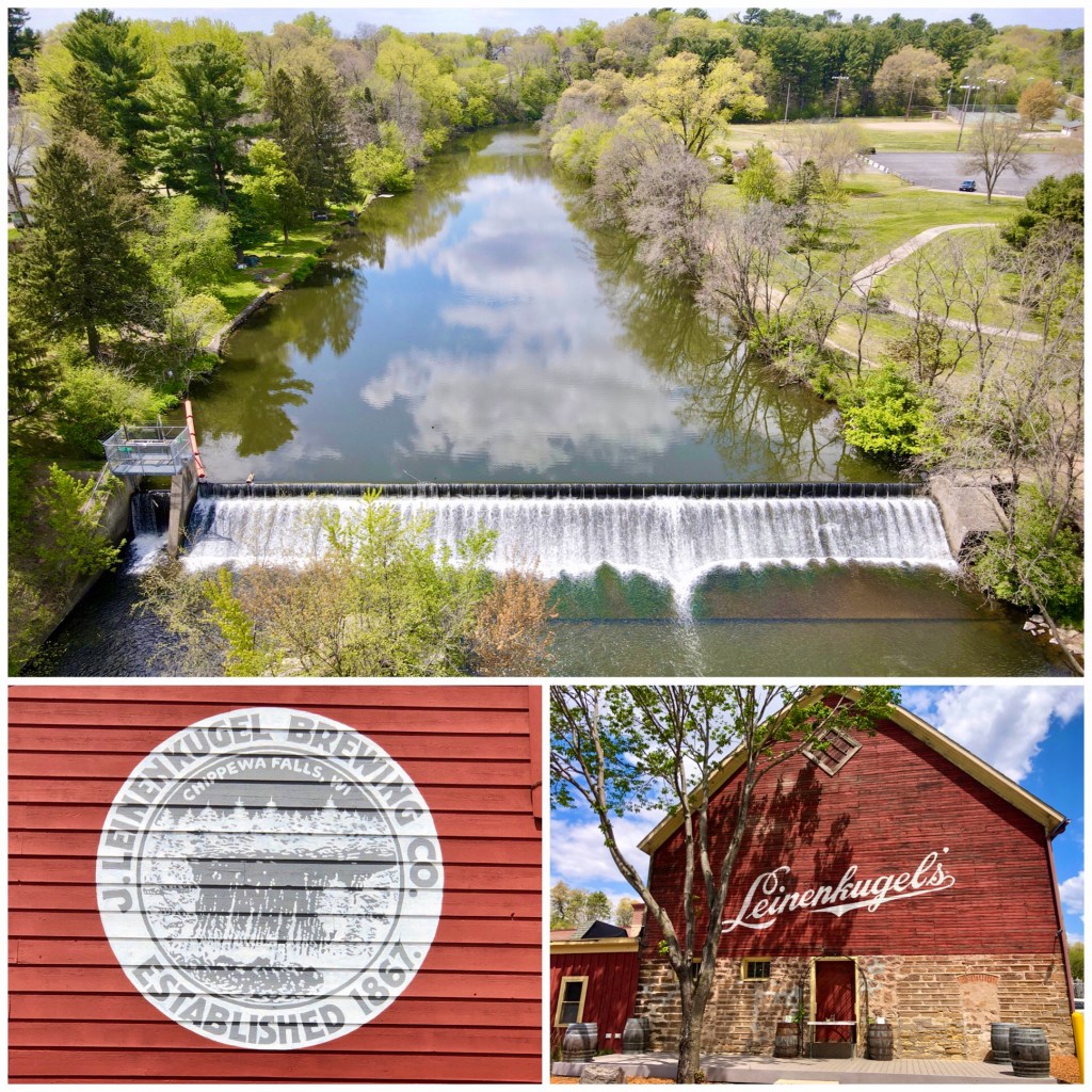
This small drop in on Duncan’s Creek alongside Marshall Park is pretty ho-hum. It is the closest waterfall to Leinenkugel’s Brewery which was founded in 1867 and continues to brew a few hundred yards away. Stopping at the Leinie Lodge and have a craft brew (or take the tour)! MAP
Glen Park Cascades (*) – River Falls WI:
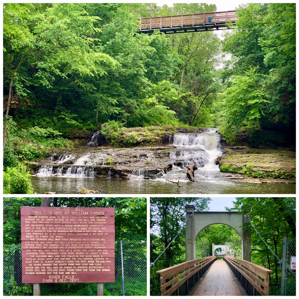
These cascades flow below the bluffs of Glen Park in River Falls, very close to the power plant. This small waterfall is a former mill falls, but it was freed about 100 years ago. The falls are spanned by a high, swing bridge you can easily access from the east side of the park. MAP
River Falls Dams (*) – River Falls WI:
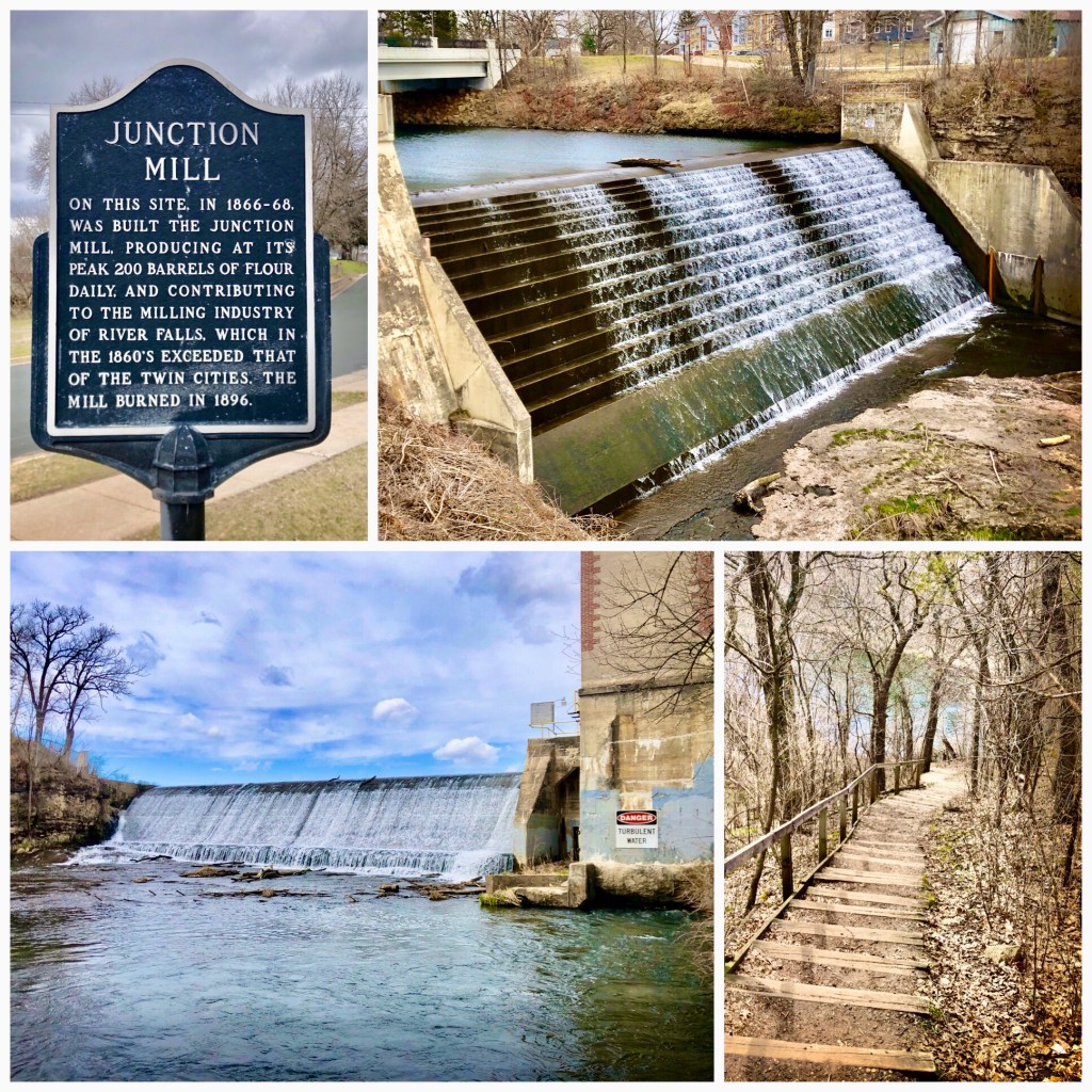
River Falls has two waterfalls on the Kinnickinnic River that have been dammed up for hydroelectric power. Following petitions to ‘Free The Kinni’, the city will soon remove the dams and restore the natural falls. Both dams can be reached from the west side of Glen Park. MAP
Devil’s Punch Bowl (**) – Menominee WI
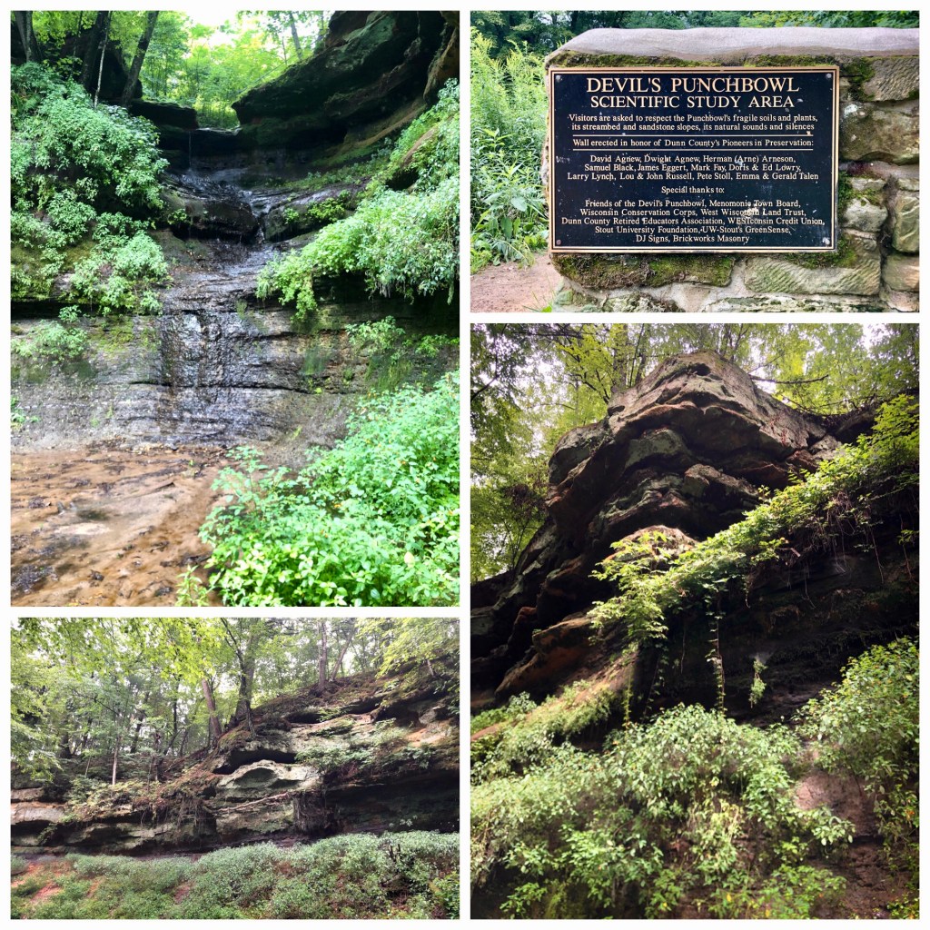
This unique, ‘Scientific Study Area’ is a mysterious bowl of sandstone, dripping water, and verdant mosses. Water falls in a unique ‘theater-in-the-round’ experience that is said to be home to fairies and trolls. It’s not much of a waterfall, but a unique place in the Wisconsin countryside. MAP
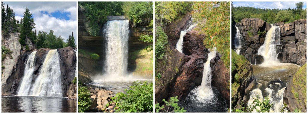
MN NORTH SHORE WATERFALLS ———————-
Gooseberry Falls (*****) – Silver Creek, MN North Shore (Mile 39):
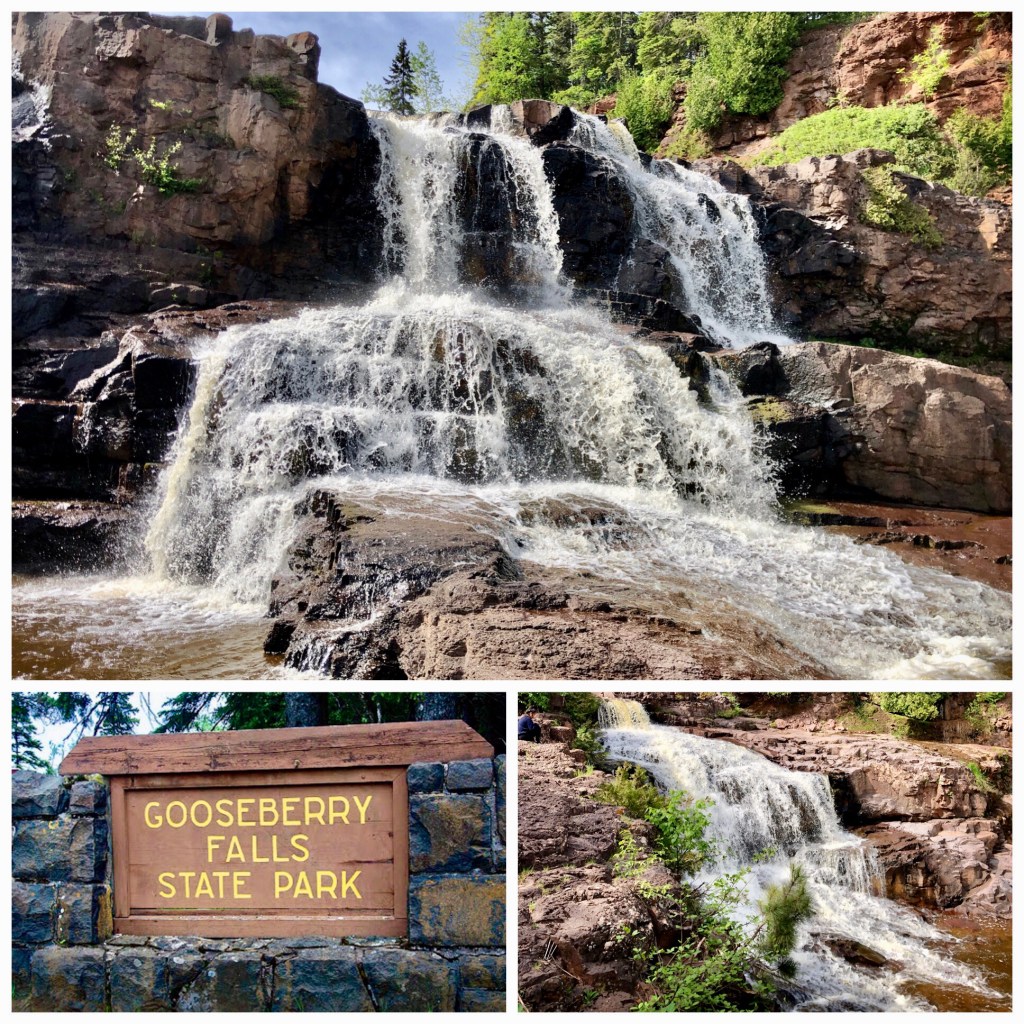
Middle & Lower Falls: Not one waterfall, but a series of outstanding drops comprise the Granddaddy of all Minnesota waterfalls, on the scenic North Shore. A short 12 mile drive from Two Harbors and right off Bob Dylan’s Highway 61, Gooseberry is one of the most-visited parks in the state. The fun of a visit to Gooseberry is climbing around the rocks and shallow water between the these falls. MAP
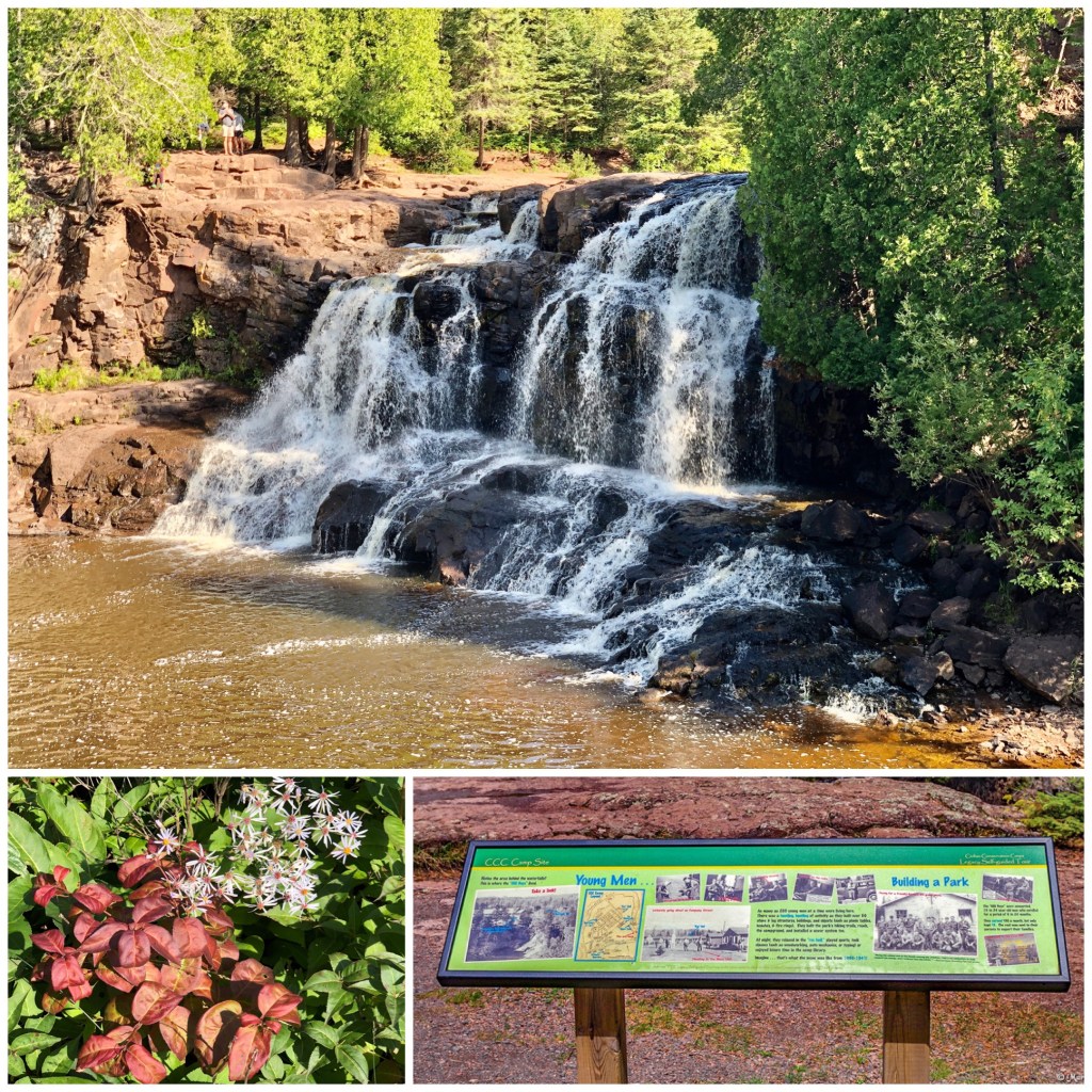
Upper Falls: Many visitors to Gooseberry Falls State Park miss the Upper Falls, just on the west side of the Highway 61 bridge. These aren’t as spectacular as the Middle & Lower Falls, but another nice sight. (Further upstream (about 1 mile) is ‘Fifth Falls’.
Glen Avon Falls (***) – Beaver Bay MN (Mile 50):
Just a couple miles inland from Highway 61 in Beaver Bay, Glen Avon is a series of waterfalls in a beautiful wooded setting. From the size of some of the tree logs deposited here, I imagine it is quite a torrent in the spring. Find the small wayside spot where a couple people can park with this link: MAP
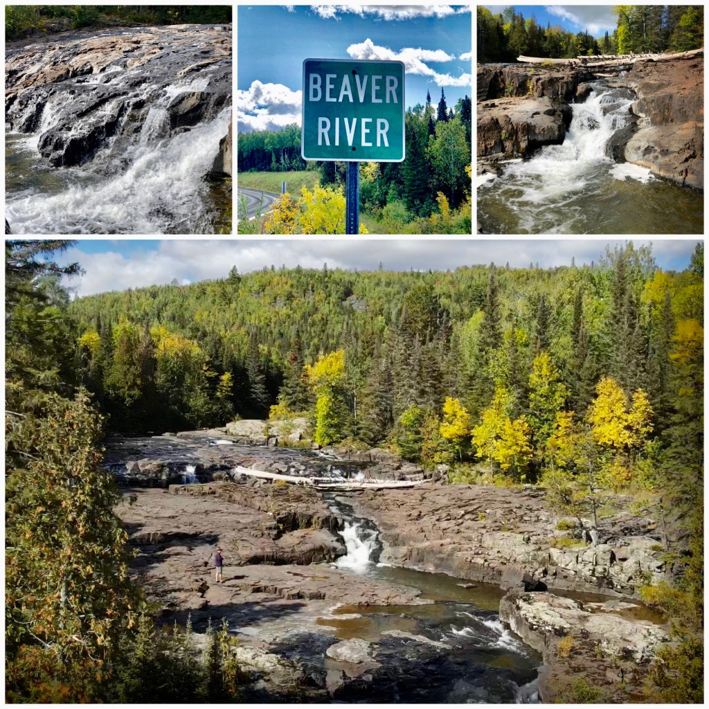
Beaver Falls (**) – Beaver Bay MN (Mile 50):
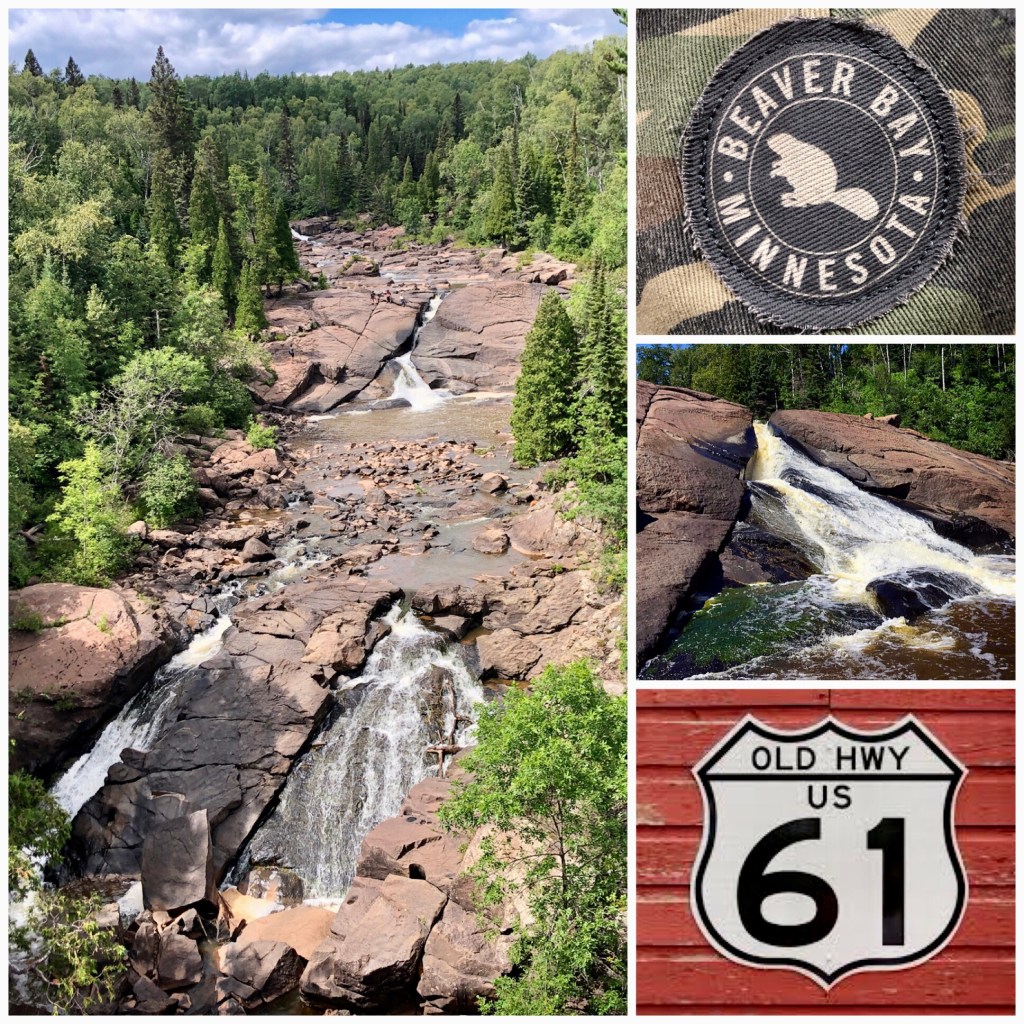
An easy stop on the North Shore, Beaver Falls is best seen from the Highway 61 Bridge in the city of Beaver Bay. There is a small park / parking lot right next to the falls. Try the nearby Camp 61 Restaurant for great slow-roasted BBQ. MAP
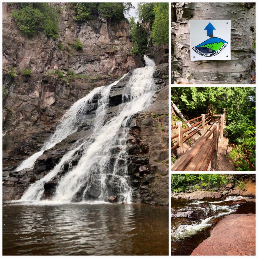
High Falls/Baptism River (****) – Tettegouche State Park (Mile 58):
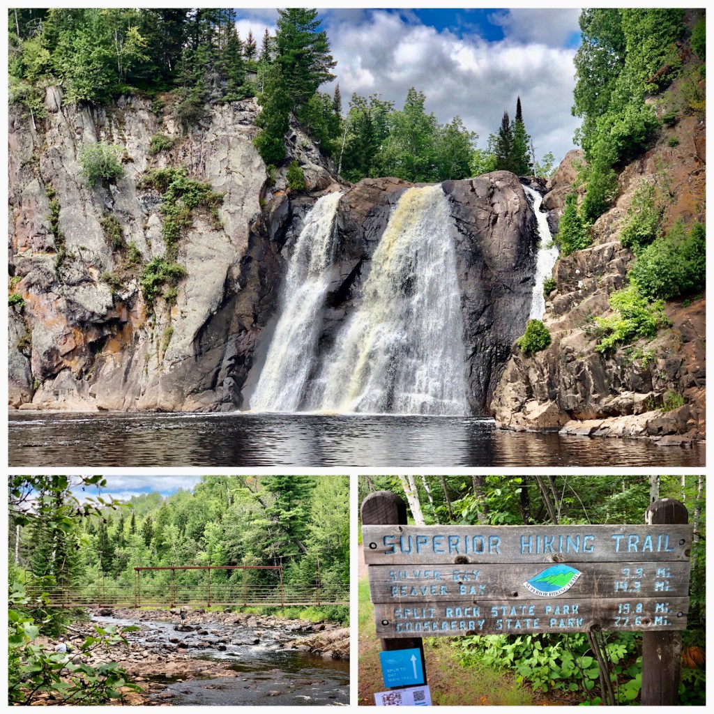
High Falls on the Baptism River in Tettegouche State Park is one of the biggest falls on Minnesota’s North Shore. A 2.0 mile hike – with a lot of elevation/stairs- takes you across a swinging suspension bridge and down to the bottom of the 60’ falls. MAP
Illgen Falls (***) – Tettegouche State Park (Mile 59):
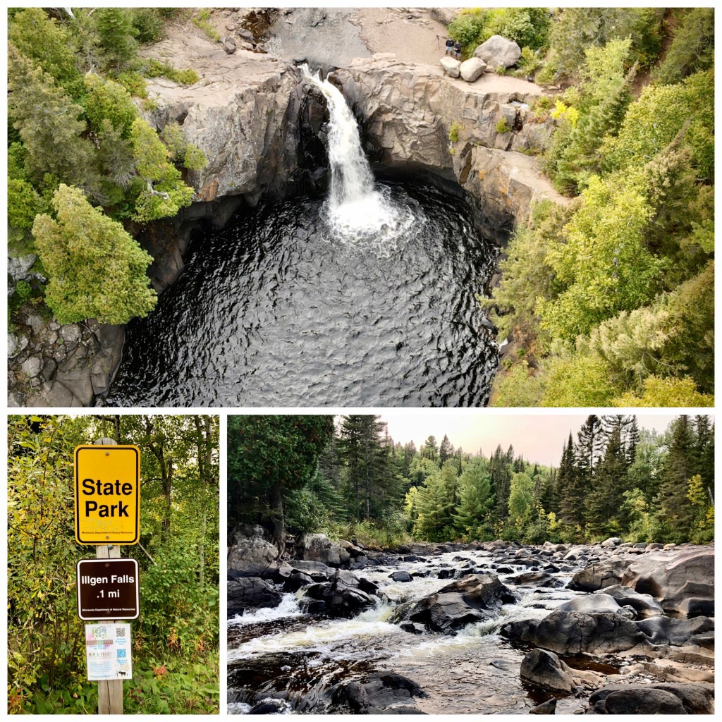
Illgen Falls is about a half-mile up from High Falls in Tettegouche State Park, but you don’t access it from the park’s trail system. Instead, go west on MN Hwy 1 about 1.5 miles from Hwy 61. You’ll see a small lay-by on the left side with a trailhead sign for Illgen Falls. It’s a very short hike 0.1 mile hile to the top of the falls. MAP
Manitou Cascades (***) – George Crosby – Manitou State Park:
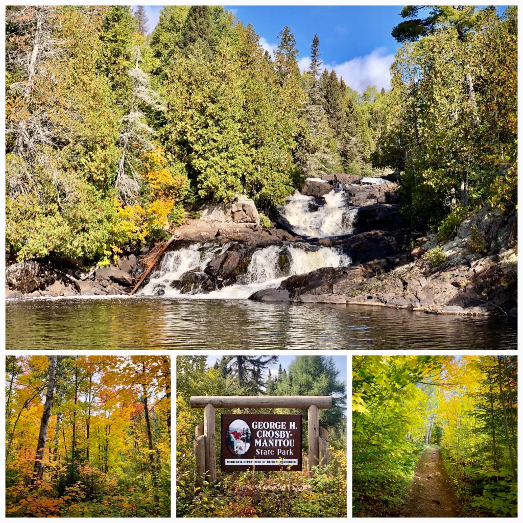
The hike on the ‘middle trail’ through George Crosby – Manitou State Park is one of the most difficult ones I’ve encountered. Lots of hills, ruts, roots, and rocks. Still, the 1 mile each-way hike is rewarded by a backcountry-wilderness view of the Manitou Cascades. They flow gently through 30-40′ of North Shore lava rock. MAP
Caribou Falls (****) – Silver Bay MN (Mile 70):
Tumbling through the rocks in a 100’ gorge, Caribou Falls is one of the most impressive falls on Minnesota’s North Shore. A short 0.6 mile hike in from the parking lot gets you to a 180-step staircase that descends to the bottom of the falls for a spectacular vantage. MAP
Two Island River Falls (***) – Schroeder MN (Mile 75):
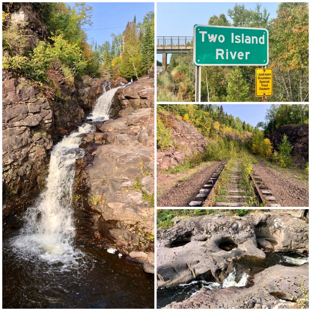
The Two Island River spills into Lake Superior near the Taconite Harbor, south of Schroeder MN. The cascades are on the west side of Highway 61, right near the old railroad trestle. Follow the water upstream, over the railroad tracks, and you’ll find the most impressive falls. Please note: there isn’t any parking here, but people pull over onto the wide shoulder or the small wayside south of the train bridge. MAP
Cross River Falls (**) – Schroeder MN (Mile 79):
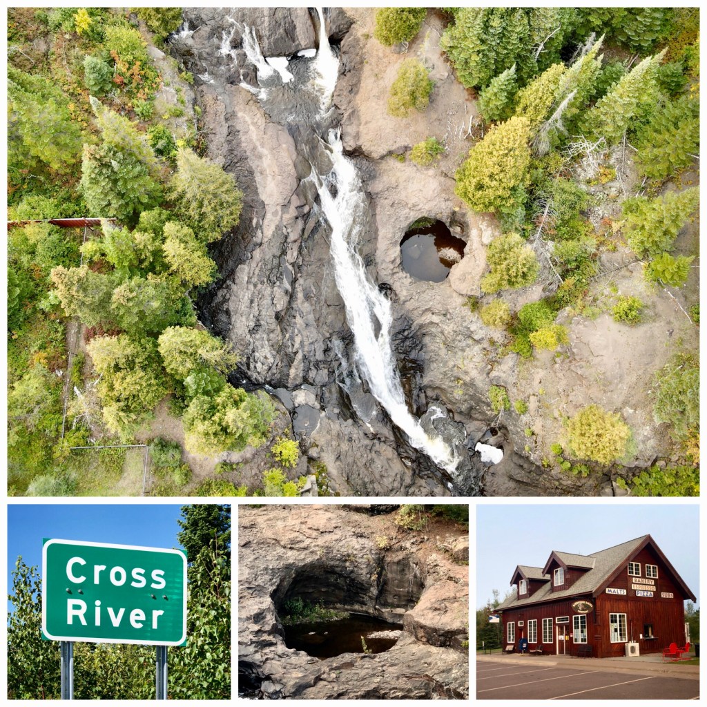
Cross River is another MN North Shore waterfall that is easy to see from Highway 61 as it cuts through the rocks near Schroeder, MN. Park in the adjoining lot or grab a treat across the road at the Schroeder Baking Company. MAP
Temperance River Falls (***) – Schroeder MN (Mile 80):
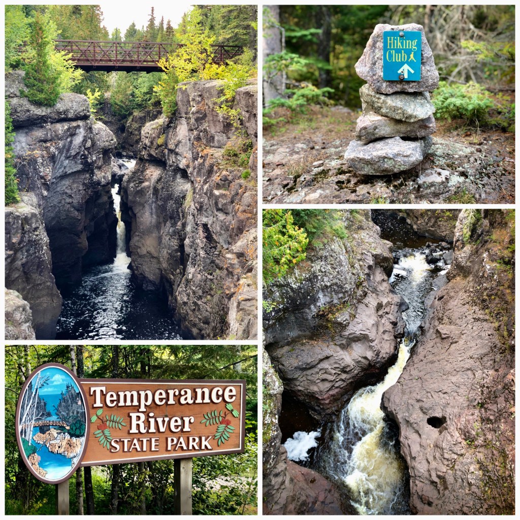
This might be the most geologically interesting park in the state. Since the last Ice Age, water has cut 160+ vertical feet through the lava rock – creating a deep, narrow gorge, multiple waterfall drops, and massive glacial potholes. Park along the Highway 61 wayside and it is a short hike into the park and up to the falls bridge. MAP
Cascade River State Park (****) – Lutsen MN (Mile 100):

Just north of Lutsen MN, Cascade Falls are a delightful group of 5 waterfalls right off Hwy 61. An easy hike up one side of the river brings you to a bridge spanning a number of them. Like Gooseberry & Temperance, this one would be great for kids – lots of places to climb around and see the river cut through the gorge. MAP
‘Devil’s Kettle’ (****) – Judge Magney State Park (Mile 124):
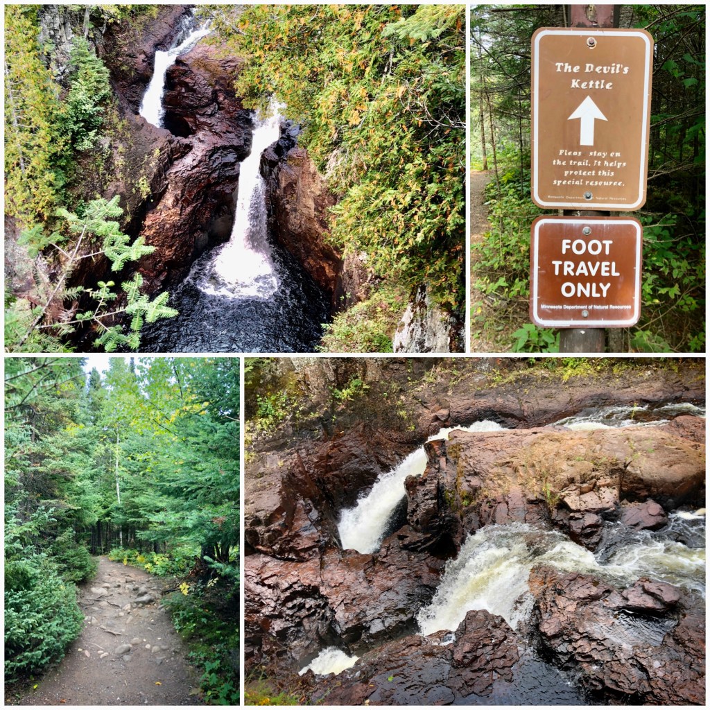
Minnesota’s most mysterious waterfall is the ‘Devils Kettle’ near the Canadian border. The Brule River splits in two on its way down – half of the water drops naturally in plain sight, the other half drops into a ‘glacial pothole’ never to be seen again. It’s quite a Devilish trick! The hike to these falls is about 1 mile, but there are three sets of steep steps: 25, 40, and 175 to get to the falls. MAP
High Falls / Brule River (***) – Judge Magney State Park (Mile 124):
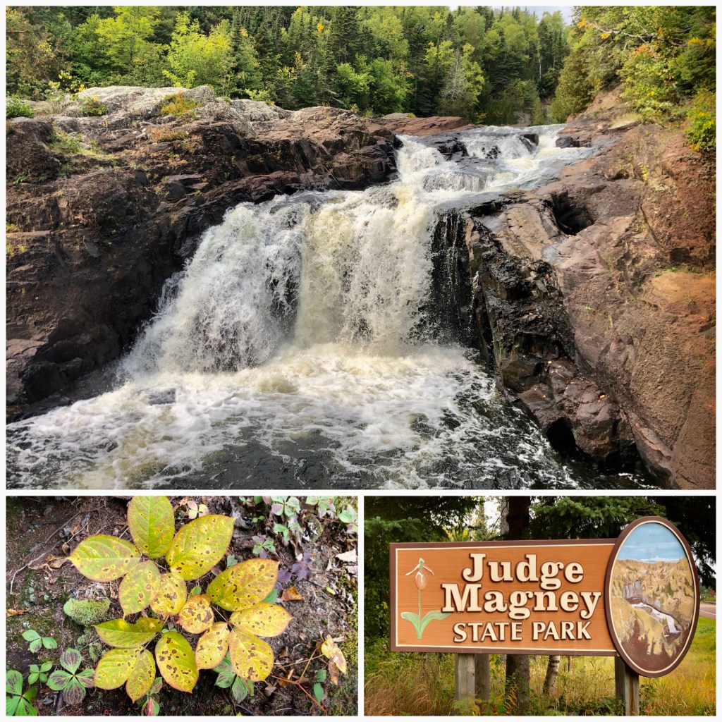
If High Falls on the Brule River was in the Twin Cities, people would rave about it. Unfortunately, it is overshadowed many other great falls on the MN North Shore – including the mysterious ‘Devils Kettle’ a few hundred yards upstream. MAP
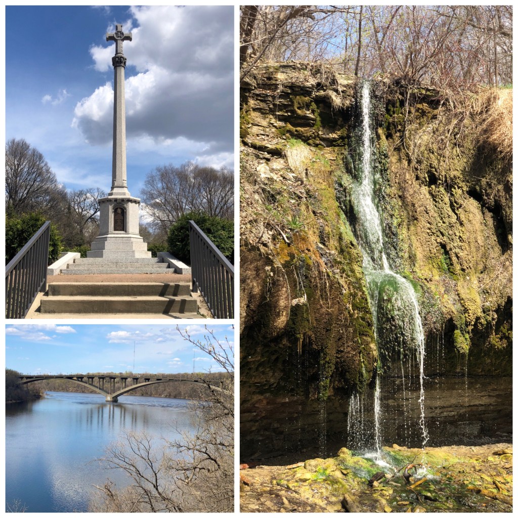
High Falls/Pigeon River (*****) – Grand Portage State Park (Mile 145):
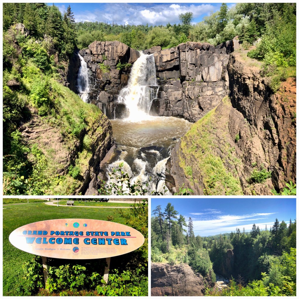
This huge 120-foot waterfall borders the Canadian border at the very top of Minnesota’s Arrowhead region. It’s a short walk (0.6 miles) from the visitors center – which features the culture of the Grand Portage Ojibway Tribe – to the High Falls overlooks. One of the easiest hikes & most spectacular views you’ll find. MAP
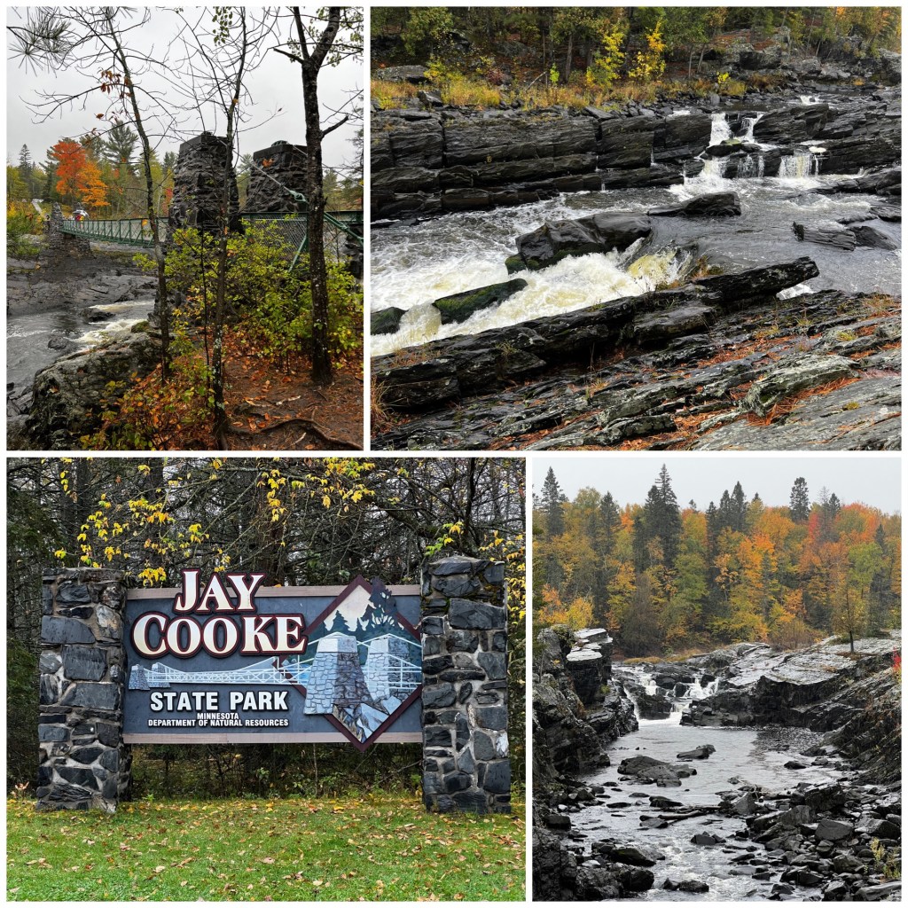
St. Louis River Cascades (****) – Jay Cooke State Park
INDIANHEAD / NORTHWEST WISCONSIN ——————-
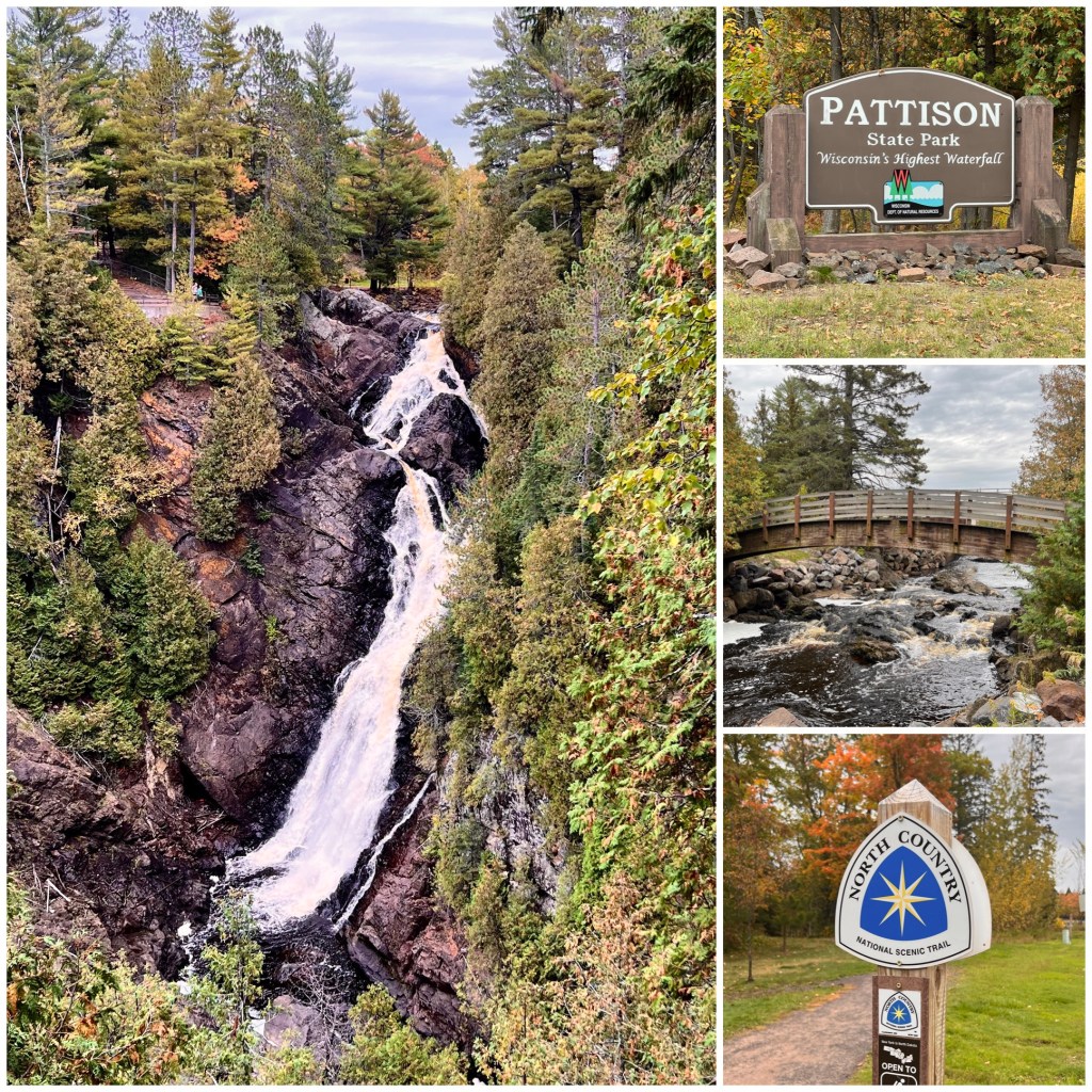
Big Manitou Falls (*****) – Pattison State Park
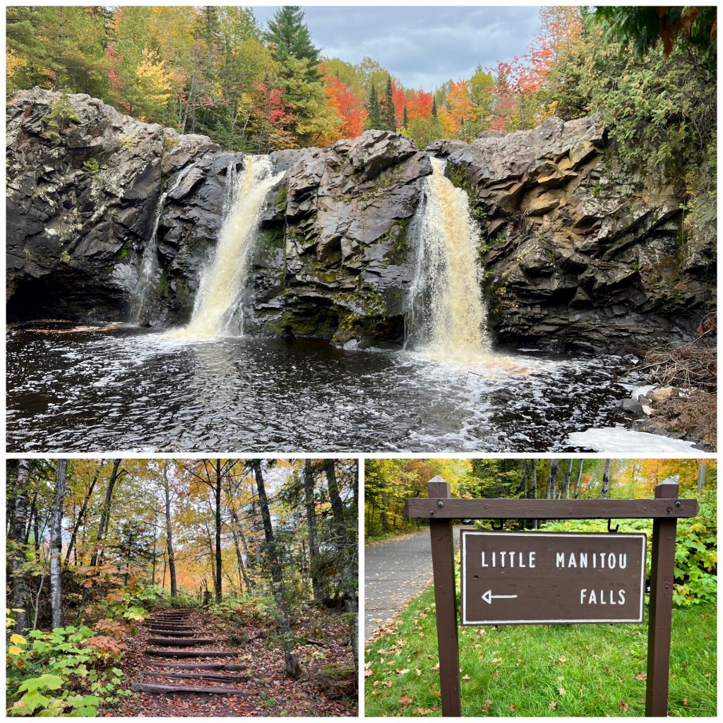
Little Manitou Falls (***) – Pattison State Park WI
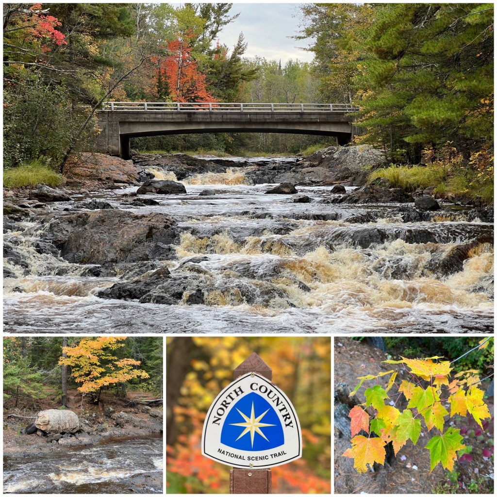
Upper & Lower Amnicon Falls (****) – Amnicon State Park
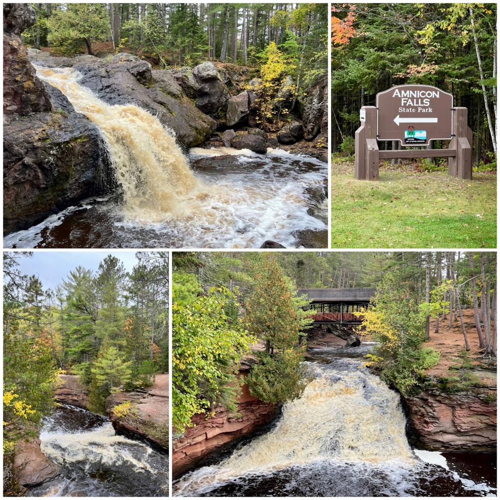
Snake Pit Falls (**) – Amnicon State Park WI
SOUTHERN MINNESOTA / IOWA WATERFALLS ———————-
Minneopa Falls (****) – Mankato MN:
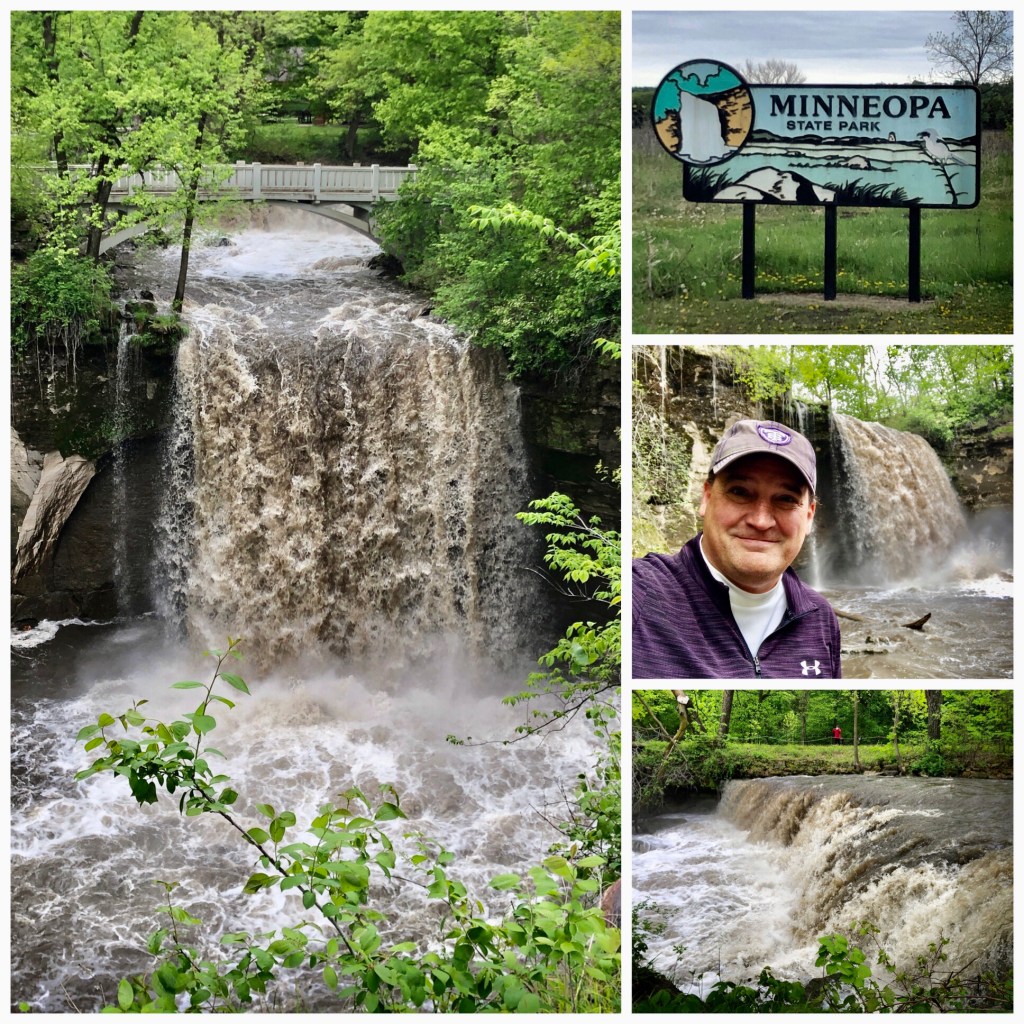
This is known as Southern Minnesota’s nicest and largest falls. It is just south of Mankato in Minneopa State Park. In addition to the fantastic falls – that you can climb above & below – the park has a herd of bison that are genetically ‘pure’. MAP
Minnesmishinona Falls (***) – Mankato MN:
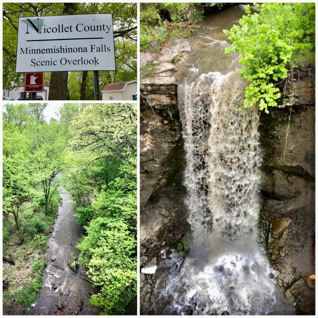
These steep falls are just 15 minutes away from the much grander Minneopa Falls, but worth a quick side trip. Parking is just off the road and the 42’ falls are viewed up-close from a nice walking bridge. MAP
Cannon River Falls (**) – Cannon Falls MN:
I’m not sure what the dividing line between ‘waterfall’ and ‘rapids’ is, but this one is getting close. Right off Main Street in Cannon Falls, this spot has a nice park for a picnic and nearby brewery & winery. MAP
Hidden Falls (**) – Big Woods State Park / Nerstrand MN:
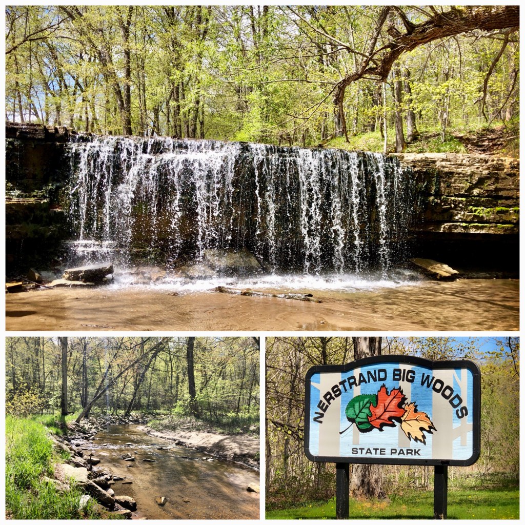
This charming, broad, waterfall is in Big Woods State Park near Nerstrand MN. It’s about a 1 hour drive from the Twin Cities. A MN State Park pass is needed to park, or you can get a day pass on-site. The hike to the waterfall is about 1/2 mile each way down a moderately steep grade. MAP
Ames Mill Falls (**) – Northfield MN:
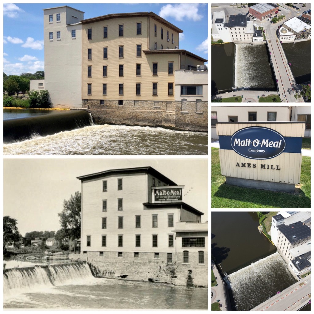
These shots of Ames Mill – home of Malt-O-Meal Cereal – were taken 90 years apart (2020 & 1930). The original mill on this Cannon River waterfall was started by John North in 1856. MAP
Caron / Wellstone Falls (*) – Faribault MN:
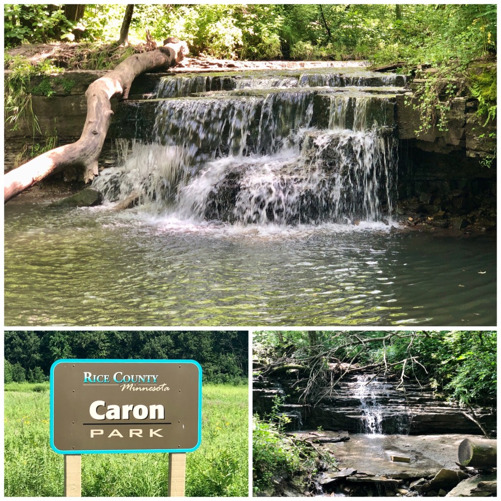
Little Caron Park is 8 miles, 1 gravel road, and 1 million mosquitoes from downtown Faribault. A couple cute little falls here in the woods. This is just a couple minutes west of Big Woods State Park and Hidden Falls. MAP
Lagoon Park Falls (**) – Jordan MN
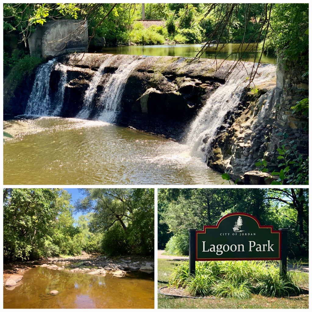
This is a small, but easily accessible waterfall on Sand Creek in Jordan’s Lagoon Park. I’ve read about another waterfall in this area, but I can’t seem to locate it. Convenient snack bar for an ice cream treat across the road from the parking area. MAP
Rhodes Mill Falls (***) – Fertile IA
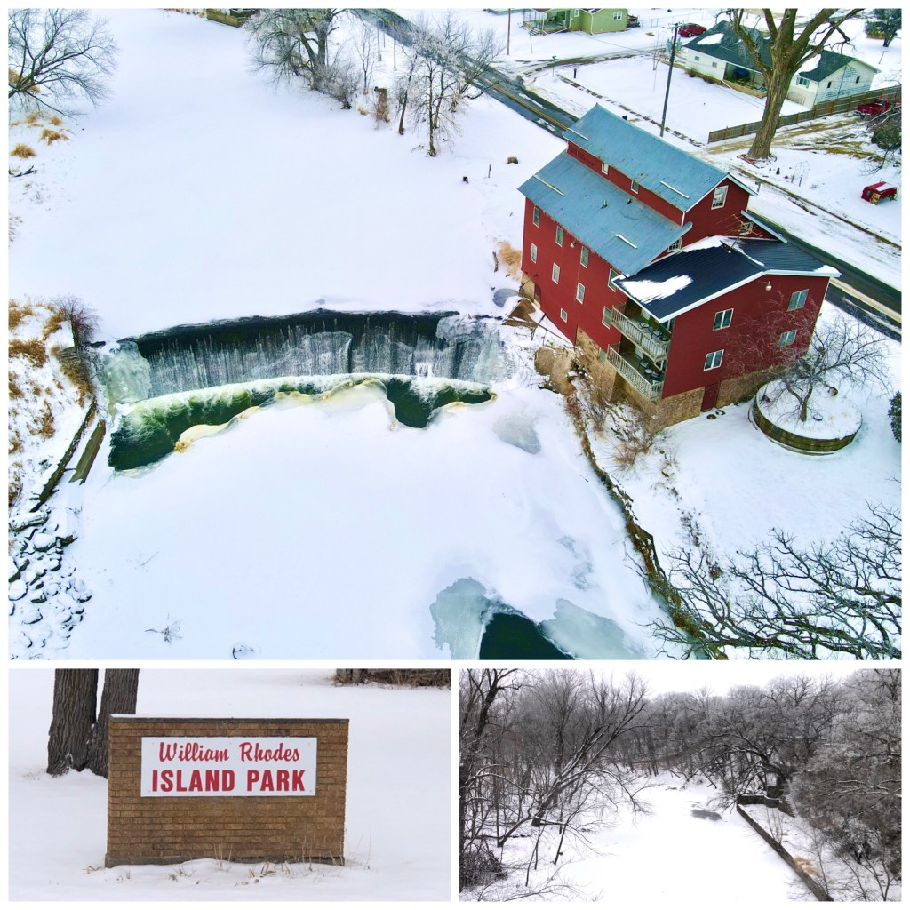
Just over the border into Iowa – a few miles west of I-35 is the tiny town of Fertile. The local joke is that the Men of nearby Manly love the fertile Women of Fertile. Thankfully, the falls & mill here are better than the local humor! The Rhodes Mill is a B&B – giving you a chance to stay right over the falls on the Winnebago River. MAP
MICHIGAN – UPPER PENINSULA
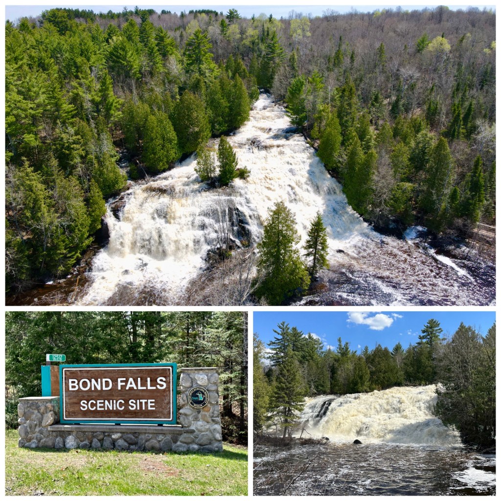
Bond Falls (*****)
Agate Falls (****)

Hungarian Falls (***)
A series of small waterfalls starts with a short hike from the road. About a half-mile off of Golf Course Road. The largest falls here is actually a spillway from a dam on Dover Creek. MAP
Eagle Falls (***)
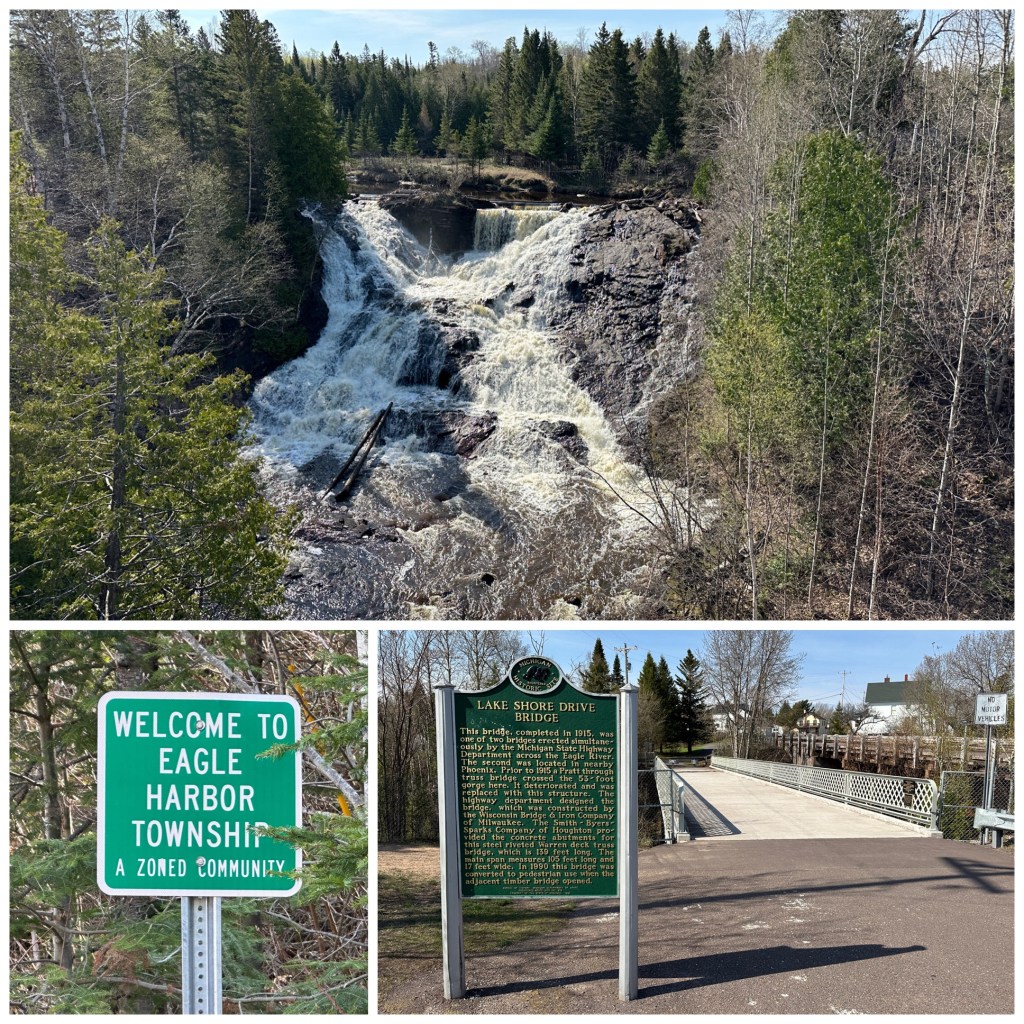
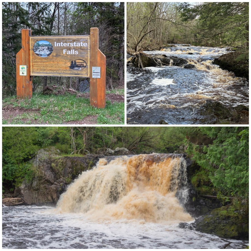
Interstate Falls (**)
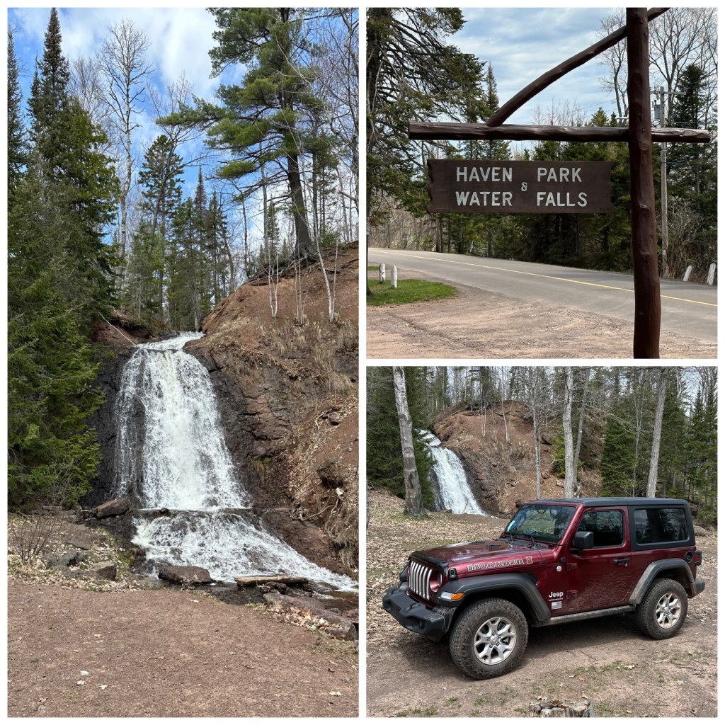
Haven Park (**)
Jacob’s Falls (*)

ONTARIO WATERFALLS – North Shore Lake Superior
Kakabeca Falls (*****)

Just about 30 minutes north of the Minnesota/ Ontario border is wonderful Kakabeca Falls. It’s a good day trip into Canada from Grand Marais. You can hit Grand Portage Falls on your way out of the USA. No hiking here. A very nice platform system gives you a good view from near the parking lot. MAP
Aguasabon Falls (****) – Schreiber, Ont
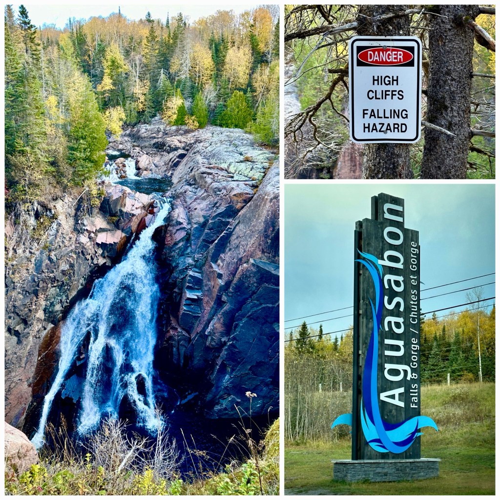
Aguasabon is a very high (100’ drop) waterfall that cuts through the top of volcanic rock. It’s a short walk from the parking area, with a very nice platform viewing area. If you follow a small path from the platform to the right (sometimes gate is locked) , there are better views – although the cliff is quite steep and unfenced. MAP
Scenic High Falls (****) – Wawa, Ontario
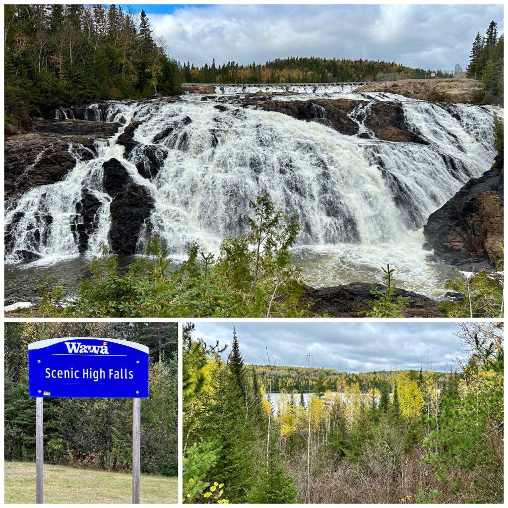
Located just a few km down a bumpy dirt road from Highway 17 / Wawa, Ontario. You can literally sit in your car and see the falls. More than 80’ wide, High Scenic is one of a few truly spectacular waterfalls off the Trans-Canada Highway. MAP
——————————————————————————————
TWIN CITIES: St Anthony Falls (*****), Minneapolis; Minnehaha Falls (****), Minneapolis; Ford Dam, (**), St Paul; Rum River Dam (**), Anoka MN; Hidden Falls (*), St Paul; Shadow Falls (*), St Paul; Coldwater Spring/Cascades, Minneapolis MN; Lake Phalen Waterfall (*), St Paul MN; Lake Bennett Waterfall (*), Roseville MN; Lake Normandale (*), Bloomington MN; Mears Park (*), St Paul MN
ST. CROIX VALLEY / WESTERN WISCONSIN: Willow River Falls (*****), Hudson WI; Fairy Falls (****), Stillwater; Vermillion Falls (***), Hastings, MN; Cascade Falls(***), Osceola WI; Robinson’s Creek Falls (**), Scandia MN; St Croix Falls / Dam (**), WI; Marine Mill Falls (*), Marine-On-St Croix; Big Falls Park (***), Eau Claire WI; Dells Millpond (***), Augusta WI; Lake Redstone Falls (**), LaValle WI; Glen Loch Spillway (**) & Star Lake Spillway (*), Chippewa Falls WI; Glen Park Cascade Falls (**) & Power Plant Dams (*), River Falls WI; Devil’s Punchbowl (**), Menominee WI
MINNESOTA NORTH SHORE / LAKE SUPERIOR: Gooseberry Falls (*****), Glen Avon Falls (***) & Beaver River Falls (***), Beaver Bay MN; Silver Creek MN; High Falls (****) & Illgen Falls (****) of Baptism River, Tettegouche State Park; Manitou Cascades (****), Geo Crosby State Park; Caribou Falls (****), Silver Bay MN; Two Island River Falls (***) & Cross River Falls (***), Schroeder MN; Temperance River Falls (****), Cascade River Falls (****), Lutsen MN; ‘Devil’s Kettle’ (****) & High Falls (***), Judge Magney State Park; High Falls (*****) of Pigeon River, Grand Portage MN; St Louis River Falls (****), Jay Cooke State Park
INDIANHEAD / NW WISCONSIN: Big Manitou Falls (*****), Pattison State Park; Little Manitou Falls (***), Pattison State Park; Amnicon Falls (****), Amnicon State Park; Snake Pit Falls (**), Amnicon State Park
SOUTHERN MINNESOTA / IOWA: Minneopa Falls, Mankato (****); Minnemishinona Falls (***), Mankato; Rhodes Mill Falls (***), Fertile IA; Cannon River Falls (**), Cannon Falls, MN; Hidden Falls (**), Nerstrand; Ames Mill Falls (**), Northfield MN; Caron/Wellstone Falls (**), Faribault MN; Lagoon Park Falls (**), Jordan MN
Thru 9/1/21: 48 (thru Lagoon Park Falls)
